
Population 2,575 (2006 census) Founded 1879 | Established 1879 Area 5,877 km² | |
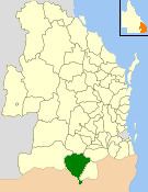 | ||
The Shire of Inglewood was a local government area of Queensland, Australia on the Queensland-New South Wales border in the Darling Downs region, about halfway between the towns of Goondiwindi and Warwick. Administered from the town of Inglewood, it covered an area of 5,876.7 square kilometres (2,269.0 sq mi), and existed as a local government entity from 1879 until 2008, when it amalgamated with the Shire of Waggamba and the Town of Goondiwindi to form the Goondiwindi Region.
Contents
History
The Inglewood Division was created on 11 November 1879 as one of 74 divisions around Queensland under the Divisional Boards Act 1879 with a population of 1378.
Following a petition by residents, the Rosenthal Division was created on 18 April 1889 under the Divisional Boards Act 1879 from Subdivision No. 1 of the Inglewood Division.
With the passage of the Local Authorities Act 1902, Inglewood Division became the Shire of Inglewood on 31 March 1903.
On 15 March 2008, under the Local Government (Reform Implementation) Act 2007 passed by the Parliament of Queensland on 10 August 2007, the Shire of Inglewood was merged with the Shire of Waggamba and the Town of Goondiwindi to form the Goondiwindi Region.
Major industries in the Shire included beef cattle, grains, export fruit, olives and wool growing.
Towns and localities
The Shire of Inglewood included the following settlements: