
Population 6,750 (1992) Area 322 km² Council seat Cobram | Established 1953 Founded 1953 | |
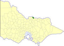 | ||
The Shire of Cobram was a local government area on the Murray River in the Goulburn Valley region, about 240 kilometres (149 mi) north of Melbourne, the state capital of Victoria, Australia. The shire covered an area of 322 square kilometres (124.3 sq mi), and existed from 1953 until 1994.
Contents
History
The Shire of Cobram's origins lay in the North West Riding of the Shire of Tungamah, which was first incorporated on 15 May 1878. Cobram's development arose from irrigation projects developed in the 1930s; after World War II, returned servicemen were allocated irrigated holdings for fruit orchards and dairy farms, and Italian immigrants also took up land in the area. A town plan was drafted in 1949, and industrial and commercial growth increased. On 1 April 1953, Cobram was severed from Tungamah, and became a shire in its own right.
On 18 November 1994, the Shire of Cobram was abolished, and, along with the Shires of Nathalia, Numurkah, Tungamah and Yarrawonga, was merged into the newly created Shire of Moira.
Wards
The Shire of Cobram was divided into four ridings, each of which elected three councillors:
Towns and localities
Population
* Estimate in the 1958 Victorian Year Book.