
Population 10,470 (1992) Area 575.2 km² | Established 1853 Shire of Barrabool Founded 1853 | |
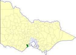 | ||
The Shire of Barrabool was a local government area about 100 kilometres (62 mi) southwest of Melbourne, the state capital of Victoria, Australia. The shire covered an area of 575.18 square kilometres (222.1 sq mi), and existed from 1853 until 1994.
Contents
History
Barrabool was incorporated as the second road district in the colony on 28 December 1853, and became a shire on 13 June 1865. On 31 May 1927, it annexed part of the Shire of Winchelsea. Its shire offices were located on Grossmans Road, near Surf Coast Highway, Torquay, although almost all of Torquay was within the City of South Barwon.
On 18 May 1993, parts of the shire were annexed to the newly created City of Greater Geelong under the premiership of Jeff Kennett. On 9 March 1994, the Shire of Barrabool was abolished, and, along with the remainder of the City of South Barwon and parts of the Shire of Winchelsea, was merged into the newly created Surf Coast Shire.
Wards
The Shire of Barrabool was divided into three ridings on 26 February 1958, each of which elected three councillors:
Towns and localities
Population
* Estimate in 1958 Victorian Year Book.