
Phone number 0480-92-1111 Population 51,684 (Feb 2016) | Region Kantō Area 24.92 km² Local time Sunday 4:14 AM | |
 | ||
Weather 3°C, Wind NW at 11 km/h, 89% Humidity Points of interest Fureainomori Park, Shishi Museum, Takaiwa Park, Fudezuka, Kodai Bridge | ||
Shiraoka (白岡市, Shiraoka-shi) is a city located in Saitama Prefecture, in the central Kantō region of Japan. As of 1 February 2016, the city had an estimated population of 51,684 and a population density of 2070 persons per km². Its total area was 24.92 square kilometres (9.62 sq mi).
Contents
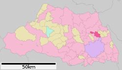
- Map of Shiraoka Saitama Prefecture Japan
- Geography
- Surrounding municipalities
- History
- Economy
- Education
- Railway
- Highway
- Local attractions
- Noted people from Shiraoka
- References
Map of Shiraoka, Saitama Prefecture, Japan
Geography
Located in the flatlands eastern Saitama Prefecture, Shiraoka is approximately 40 kilometers from downtown Tokyo.
Surrounding municipalities
History
The villages of Shinozu and Oyama were created within Minamisaitama District, Saitama with the establishment of the municipalities system on April 1, 1889. On September 1, 1965 Shinozu and the neighboring village of Hikachi, together with a part of Oyama merged to form the town of Shiraoka. Shiraoka was elevated to city status on October 1, 2012.
Economy
Shiraoka remains primarily an agricultural community; however due to its location, it is increasingly becoming a bedroom community for neighboring Saitama City and the Tokyo metropolis.
Education
Shiraoka has six elementary schools, four middle schools and one high school.