
District Suntō Area 8.81 km² Local time Saturday 11:12 PM | Region ChūbuTōkai Phone number 055-973-1111 Population 32,091 (Sep 2015) | |
 | ||
Weather 5°C, Wind N at 21 km/h, 89% Humidity Points of interest Kakita River Park, Honjoyama, Hochidera | ||
Shimizu (清水町, Shimizu-chō) is a town in Suntō District of Shizuoka Prefecture, Japan. As of September 2015, the town had an estimated population of 32,091 and a population density of 3,640 persons per km2. The total area was 8.81 square kilometres (3.40 sq mi).
Contents
- Map of Shimizu Sunto District Shizuoka Prefecture Japan
- Geography
- Neighboring municipalities
- History
- Economy
- Education
- Transportation
- Sister cities
- Local attractions
- References
Map of Shimizu, Sunto District, Shizuoka Prefecture, Japan
Geography
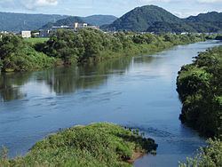
Shimizu is located at the northern end of Izu Peninsula. The Kakita River flows through the town. The area has a temperate maritime climate with hot, humid summers and mild, cool winters.
Neighboring municipalities
History
Shimizu is located in the far eastern portion of former Suruga Province, and was largely tenryō territory under direct control of the Tokugawa shogunate in the Edo period. During the cadastral reform of the early Meiji period in 1889, the area was reorganized into the village of Shimizu within Suntō District, Shizuoka through the merger of 11 small hamlets.
Shimizu attained town status in 1963. There have been numerous attempts to merge Shimizu into neighboring Numazu (1966, 1967, 1996, 2003, 2004, 2006 and 2007).
Economy
The economy of Shimizu is largely based on agriculture. The town also serves as a bedroom community for the industrial zones in neighboring Numazu and Mishima.
Education
Shimizu has three elementary schools, two middle schools, and one high school.
Transportation
Japan National Route 1 passes through Shimizu. The town does not have any passenger railway connections.