
Population 4,998 (2011 census) | Postcode(s) 4075 Postal code 4075 | |
 | ||
Location 8.2 km (5 mi) from Brisbane CBD State electorate(s) Mount OmmaneyIndooroopilly Federal divisions Division of Moreton, Division of Oxley | ||
Sherwood is a suburb of the City of Brisbane, Queensland, Australia. It is 8.3 kilometres (5.2 mi) south west of the Brisbane CBD and borders the Brisbane River. The suburb is mostly low and medium-density housing with a retail strip centred along Sherwood Road. At the 2011 Australian Census the suburb recorded a population of 4,998.
Contents
- Map of Sherwood QLD 4075 Australia
- Demographics
- Heritage listings
- Commercial area
- Transport
- Education
- Clubs
- References
Map of Sherwood QLD 4075, Australia
Demographics
In the 2011 census, the population of Sherwood was 4,998, 52.5% female and 47.5% male. The median age of the Sherwood population was 36 years, one year below the Australian median. 71.9% of people living in Sherwood were born in Australia, similar to the national average of 69.8%. The other top responses for country of birth were England 4.7%, New Zealand 2.9%, India 1.3%, South Africa 0.7%, Philippines 0.7%. 84.9% of people spoke only English at home; other languages include 0.9% Mandarin, 0.6% Cantonese, 0.6% Vietnamese, 0.5% Tagalog, 0.5% Spanish.
Heritage listings
Sherwood has a number of heritage-listed sites, including:
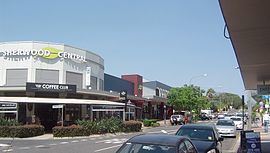
Commercial area
There are a number of cafes, including the Coffee Club, and a Woolworths supermarket.
Transport
The suburb is serviced by the Sherwood Railway Station which links Ipswich and the Springfield Central lines to the Brisbane central business district. Bus services along Oxley Road link the Centenary suburbs to Indooroopilly and the Great Circle Line service passes through the suburb.
Education
Sherwood State School, established in 1867 is one of the oldest schools in the state and still has preserved many of its original timber buildings.
Sherwood State School was originally known as West Oxley State School and opened on 25 March 1867 (other records indicate 23 March). The first head teacher (Headmaster) appointed to the school was Major William Jenyns Boyd. He was born in Paris in 1842 and migrated to Australia in 1862.
In 1868, Oliver Radcliffe was the first name on the roll as a pupil teacher. He became a teacher, a headmaste and then a school inspector. By his retirement in 1932, he was the Chief Inspector for the Queensland Education Department. He personally inspected schools from Coolangatta to Thursday Island and from Rockhampton to the border with South Australia.
Other significant 'finger prints' in Sherwood State School's heritage include:
1874 – School builds first Water Closet (toilet);
1878 – School changed its name to Sherwood State School.
1890 – Shingle roofing replaced with corrugated iron;
1893 – Measles and influenza out break reported;
1914 – World War 1;
1917 – Three additional classrooms added;
1925 – Students planted 100 trees in school grounds;
1926 – Limited electricity was provided;
1927 – 33 additional 3 acres (12,000 m2) of land purchased;
1928 – First telephone installed
1936 – Three more classrooms added; electrical gramophone and wireless (radio) provided to the school
1937 – School moved to its current location/site.
1939 – World War II began with a first aid, ambulance post and air raid trenches placed under buildings;
1950 – Polio outbreak;
1959 – School enrolment peaked at 1034 students;
1962 – Tuck Shop opened;
1965 – Parent and Citizen's Association was formed; tennis court resealed and fenced;
1967 – Pool opened;
1984 – School purchased first computer;
1991 – After school care services established;
2000 – School Hall opens;
2006 – Preparatory building constructed
2007 – Inaugural prep class commences
2012 – New Sports Hall
Clubs
The Sherwood Sharks swimming club uses the Sherwood State School Pool.