
Area 114 ha Zip code 43065 Local time Friday 6:34 PM | Elevation 272 m Population 723 (2013) Area code 614 | |
 | ||
Weather 10°C, Wind NW at 21 km/h, 97% Humidity | ||
40 e old powell road shawnee hills powell oh home for sale listed by susanne novak re max 24 7
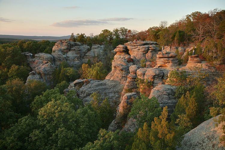
The Shawnee Hills is a region of southern Illinois that rests mainly in an east-west arc roughly following the outline of the southern end of the Illinois Basin. Whereas Mississippian and Pennsylvania Age rock layers are deep beneath the surface in central Illinois, these strata pierce the surface in southern Illinois. The Shawnee Hills are surface expressions of the more weather resistant limestone and sandstone layers.
Contents
- 40 e old powell road shawnee hills powell oh home for sale listed by susanne novak re max 24 7
- Map of Shawnee Hills OH 43065 USA
- Experience the shawnee hills wine trail
- References
Map of Shawnee Hills, OH 43065, USA
Within the Shawnee Hills, limestone is extensively quarried from outcrops, while both north and south of the Shawnee Hills, coal is mined by surface techniques on shallow coal seams near the edges of the Illinois Basin and by deep mining techniques in the deeper parts of the Basin. Additionally, extensive faulting in and around the Shawnee Hills occurred due to deep tectonic activities and formed sites for deposition of fluorite, a mineral used for production of the element fluorine. At one time, about 80% of the world's fluorspar (the limestone ore containing fluorite) was mined near the towns of Rosiclare and Cave in Rock.
A large portion of the Shawnee Hills lies within the Shawnee National Forest; one of the largest protected Federal forests in the United States. The beauty of the Shawnee Hills, the Shawnee National Forest, and the Ohio River Valley make the area a prime tourist destination.
The Shawnee Hills can be seen faintly from as far north as Vergennes. The westernmost portion of the hills rise south of Murphysboro and continue southward to Olive Branch. Large plains used for farmland separate the hills from the Mississippi River along Illinois Route 3, especially near the towns of Wolf Lake, Grand Tower and Ware. The Big Muddy River cuts through the hills south of Kinkaid Lake, making rocky cliffs that can be viewed by boat-ride down the river.
Though the Shawnee Hills are commonly called the "Illinois Ozarks," they are generally not considered part of the true Ozarks, which begin just to the west across the Missouri line.