
Elevation 580 m | ||
 | ||
Location Palitana, Bhavnagar district, Gujarat Similar Sandakphu, Nanda Devi, Kala Patthar, Aravalli Range, Parasnath | ||
Shatrunjaya ("place of victory against inner enemies") originally Pundarikgiri), also spelt Shetrunjaya are hills located by the city of Palitana, in Bhavnagar district, Gujarat, India. They are situated on the banks of the Shetrunji River at an elevation 164 feet (50 m) above sea level. These hills have similarities to other hills where Jain temples have been built in Bihar, Gwalior, Mount Abu and Girnar.
Contents
Map of Shatrunjaya, Dungarpur, Gujarat 364270
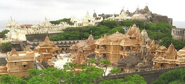
The Jain's sacred site of Shatrunjaya contains hundreds of Palitana temples. The hills were sanctified when Rishabha, the first tirthankara of Jainism, gave his first sermon in the temple on the hill top. The ancient history of the hills is also traced to Pundarika Swami, a chief Ganadhara and grandson of Rishabha, who attained salvation here. His shrine located opposite to the main Adinath temple, built by his son Bharata, is also worshiped by pilgrims.
There are several alternate spellings, including Śatruñjaya, Satrunjaya, Shetrunja, and Shetrunjo. Shatrunjaya was also known as Pundarikgiri as Pundarik was said to have attained nirvana on this mountain. Alternate names include Siddhakshetra or Siddhanchal as many thirtankaras are stated to have received enlightenment here.
EtymologyEdit
Jains refer to their temples as derasaras. Shatrunjaya, the name for Mount Shatrunjaya where it is located, means a "place of victory" or "which conquers enemies".
GeographyEdit
The Gulf of Khambhat is to the south of the Shatrunjaya Hills, Bhavnagar town is to its north, and a river flows between the two hills. Legend states that the hill is a part of the Himalayas. A path along the ridge leads down to the Adipur valley, a distance of 13 kilometres (8.1 mi). Palitana town is at the base of the foothills, 56 kilometres (35 mi) from Bhavanagar. The topography is rugged while the landscape is drought-affected.
CultureEdit
The hills were considered a thirtha (religious divine place) even before AD (expected before crores of years). The Palitana temples, a pilgrimage complex on both hills and their saddle, are reached by climbing approximately 3750 stone steps, which are carved into the mountain. The climb is 3.5 kilometres (2.2 mi) from the base and takes approximately two hours. The hills are closed to pilgrims for four months during the monsoon season. The pilgrimage is known as "Shri Shantrunjay Teerth Yatra". It occurs from the Poornima day (Full Moon Day) of Kartik month according to the Hindu calendar (October–November as per the Gregorian calendar). Jains assemble at the foot of the hills to undertake the yatra (religious journey). During this yatra, considered a great event in the lifetime of a Jain, pilgrims circumambulate the Shatrunjaya hills covering a distance of 216 kilometres (134 mi) on foot, offering prayers.