
- elevation 853 ft (260 m) Discharge 4.927 m³/s Basin area 572.4 km² | - elevation 950 ft (290 m) Length 28 km Basin area 572.4 km² | |
 | ||
- left East Branch Shade River Mouths | ||
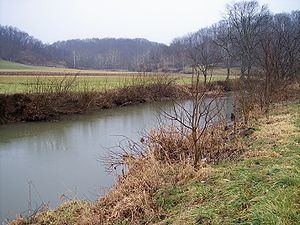
The Shade River is a tributary of the Ohio River in southeastern Ohio in the United States. Via the Ohio River, it is part of the watershed of the Mississippi River, draining an area of 221 square miles (570 km2) on the unglaciated portion of the Allegheny Plateau. The Shade River is 17.4 miles (28.0 km) long, or 38.2 miles (61.5 km) including its west branch.
Contents
Map of Shade River, Ohio, USA
The Shade River flows predominantly as three streams, its east, middle, and west branches. It is formed by the confluence of its middle and west branches, and collects its east branch shortly thereafter:
From the confluence of the middle and west branches in Chester Township, the Shade River flows generally eastwardly, past the community of Chester. It collects its east branch from the north at the community of Keno, and enters the Ohio River in Olive Township, approximately one mile (2 km) south of the community of Long Bottom.
According to the Geographic Names Information System, the Shade River has also been known historically as "Shade Creek" and as "Devils Hole Creek."
Flow rateEdit
At the United States Geological Survey's stream gauge downstream of Chester, the annual mean flow of the river between 1965 and 2012 was 174 cubic feet per second (5 cubic meters per second). The highest recorded flow during the period was 15,600 cfs (442 m³/s) on March 2, 1997. The lowest recorded flow was 0.00 cfs (0 m³/s) on September 5, 2007.