
- right Weems Creek, Spa Creek - elevation 0 ft (0 m) | Length 23 km | |
 | ||
Bridges | ||
The Severn River is a tidal estuary 14 miles (23 km) long in Anne Arundel County in the U.S. state of Maryland, south of the Magothy River and north of the South River.
Contents
- Map of Severn River Maryland USA
- GeographyEdit
- TributariesEdit
- ProvidenceEdit
- Severn River area publications and forumsEdit
- References
Map of Severn River, Maryland, USA
GeographyEdit
The Severn has a watershed area (including the water surface) of 81 square miles (210 km2), or 69 square miles (180 km2) of land. Thus, its total watershed area is 15% water. Its source is the beginning of the non-tidal nine-mile long Severn Run in northwestern Anne Arundel County in Severn, Maryland. The river enters the Chesapeake Bay near the major port city of Annapolis, also the capital of Maryland. Most famous for the United States Naval Academy campus situated at the mouth of the river, the Severn provides an access point to the Chesapeake Bay not just for midshipmen but also for fishermen and pleasure boaters. Several tributary creeks drain highly developed areas, including Weems Creek and its nontidal portion Cowhide Branch, which drain most of the Annapolis Mall and the Anne Arundel Medical Center.
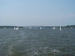
The Severn River is crossed by two bridges. One, known as the Severn River Bridge or Pearl Harbor Memorial Bridge, carries US 50/US 301/MD 2 and was first built in 1886. The other carries MD 450, and is now officially named the "US Naval Academy Bridge" because its south end traverses the academy. The latter bridge was built as a drawbridge in the late 1920s and replaced with the current high span in 1994. A former railroad trestle between the two current bridges, built in about 1887 for the Annapolis and Baltimore Short Line Railroad (which became part of the Washington, Baltimore and Annapolis Electric Railway), was removed post-1968 when it was declared unsafe.
TributariesEdit
If a tributary has sub-tributaries (commonly the upper, nontidal portion) below, they are listed after the "&".
ProvidenceEdit
Providence, the first colonial settlement in Anne Arundel County, was founded in the fall and winter of 1649–1650 at the beginning of a mass migration of a group of Puritans and non-conformists from Lower Norfolk County in Virginia to primarily the north side of the mouth of the Severn. It faded away after the 1680's when Annapolis came into favor and, in 1694, became Maryland's capital. This "lost town" of Providence was originally though to be limited to the Carr Creek and Greenbury Point area across the river from Annapolis on what are now the grounds of Naval Station Annapolis (renamed North Severn Complex.) More recent archaeological research has uncovered homes of this scattered settlement further to the north and northeast as well, on the southern half of the Broad Neck Peninsula, especially near Whitehall Creek.