
District Ōshima Population 9,379 (1 Jun 2013) | Area 239.9 km² Local time Thursday 9:31 PM | |
 | ||
Weather 18°C, Wind S at 14 km/h, 82% Humidity | ||
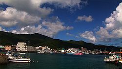
Setouchi (瀬戸内町, Setouchi-chō) is a town located primarily on Amami Ōshima, in Ōshima District, Kagoshima Prefecture, Japan.
Contents
- Map of Setouchi Oshima District Kagoshima Prefecture Japan
- Geography
- Surrounding municipalities
- History
- Economy
- Ports
- Highway
- Noted people from Setouchi
- References
Map of Setouchi, Oshima District, Kagoshima Prefecture, Japan
As of June 2013, the town had an estimated population of 9,379 and a population density of 39.1 persons per km². The total area was 239.91 km².
Geography
Setouchi occupies the southern portion of Amami Ōshima, facing the East China Sea to the east and the Pacific Ocean to the west. It also includes numerous offshore islands of Amami Ōshima, including the inhabited islands of Kakeromajima, Ukejima and Yoroshima.
The climate is classified as humid subtropical (Köppen climate classification Cfa) with very warm summers and mild winters. Precipitation is high throughout the year, but is highest in the months of May, June and September. The area is subject to frequent typhoons.
Surrounding municipalities
History
Higashikata Village was established on April 1, 1908. It became the town of Koniya on April 1, 1936. As with all of the Amami Islands, the village came under the administration of the United States from July 1, 1946 to December 25, 1953. On September 1, 1956 Koniya merged with three neighboring villages to form the town of Setouchi.
Economy
The town economy is primarily based on agriculture, with sugar cane and citrus horticulture as the main crops, and commercial fishing. Industries include shochu refining