
Country Venezuela | ||
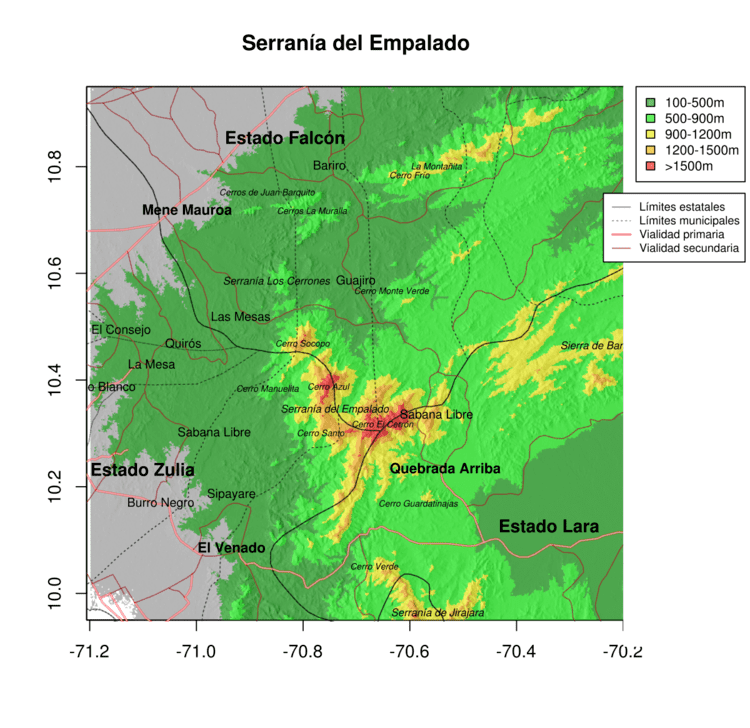 | ||
The Serranía del Empalado, also referred as serranía de Siruma or Ciruma, forms part of the system Coriano or Lara-Falcón-Yaracuy formation in Venezuela. It is a mountainous chain relatively high, small and isolated. It is separated of the Serranía of Jirajara, south, by lower heights to the 900m; of the Sierra of Baragua, to the east, by the Depression of Carora; and of the Sierra of Saint Luis by the valley of the river Matícora.
Contents
Map of Serrania del Empalado, Falc%C3%B3n, Venezuela
It is conformed by two macizos joined by relatively high valleys. The Socopó, or Socopo hill, has an area of 38,4 km² above the height of 900 m and a maximum height of 1571 m. The macizo conformed by Cerro Azúl and the Cerrón, has an area of 508,3 km² and a maximum height of 1900 m.
It is considered the natural oriental limit of the basin of the Lake of Maracaibo, and from the 19th century has served to delineate the administrative limit of the provinces of Coro, Maracaibo and Barquisimeto. It is currently located at the border of the Venezuelan states Falcón, Lara and Zulia. It is also considered the north-western limit of the extinct jirajaranas language.
Vegetation
The original vegetation is predominantly dry forest, although there are remainders of cloud forest.
It is home to emblematic trees like Gyranthera caribensis and palms Attalea butyracea (Mutis ex L.f.) Wess.Boer. or Geonoma interrupta (Ruiz & Pav.) Mart.
Fauna
At least three species of frogs are consider endemic of this Serranía: Dendropsophus amicorum, Mannophryne lamarcai and Leptodactylus magistris. Other, widespread species of frogs are also found, such as Hyla crepitans, Bufo marinus, Phyllomedusa trinitatis, Phrynohyas venulosa and Physalaemus pustulosus.