
Peak Cerro Chiribiquete Length 125 km (78 mi) State/Province Caquetá, Guaviare | Elevation 800 m (2,600 ft) Width 30 km (19 mi) Country Colombia | |
 | ||
Similar Chiribiquete National Park, Serranía de la Macarena, Serranía del Baudó, Serranía del Darién, Serranía de Macuira | ||
Ampliaci n parque nacional natural de la serran a de chiribiquete
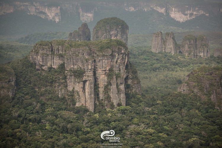
The Serranía de Chiribiquete or Chiribiquete Mountains are a group of isolated table mountains in the Amazon Region of Colombia. The mountains are part of the western edge of the Guiana Shield. The area is protected as a national park. This area is habitat for the Chiribiquete emerald (Chlorostilbon olivaresi), an endemic hummingbird. The waterfall Caño Paujil originates from the Serranía de Chiribiquete.
Contents
- Ampliaci n parque nacional natural de la serran a de chiribiquete
- Map of Serrania de Chiribiquete Calamar Guaviare Colombia
- Parque nacional natural serran a de chiribiquete
- Protected area
- References
Map of Serrania de Chiribiquete, Calamar, Guaviare, Colombia
Parque nacional natural serran a de chiribiquete
Protected area
The Chiribiquete National Park is the largest national park of Colombia with 27,000 square kilometres (10,000 sq mi) and hosts important archaeological evidences in the form of rock art. More than 600,000 traces of around 20,000 petroglyphs and pictographs have been discovered in the remote mountain chain, the oldest of which may date to 20,000 years BP. The rock art has been produced until the 16th century. The first researcher who noted the cave paintings, was the American botanist Richard Evan Schultes in the 1940s. Later investigations were carried out by Thomas van der Hammen. The Serranía de Chiribiquete is featured in the 2015 documentary Colombia, magia salvaje.
In 2014, a Colombian photographer and explorer, Francisco Forero Bonell, located and filmed previously reported ancient paintings on rock faces within the park.