
Area rank 315 in Norway Area 226.1 km² Local time Monday 2:31 AM | Administrative centre Selje Demonym(s) Seljeværing Population 2,789 (2013) Administrative center Selje | |
 | ||
Weather 7°C, Wind S at 48 km/h, 100% Humidity | ||
Selje is a municipality in the county of Sogn og Fjordane, Norway. It is located in the traditional district of Nordfjord. The village of Selje is the administrative center of Selje municipality.
Contents
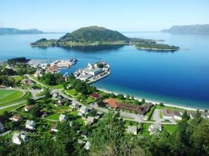
- Map of 6740 Selje Norway
- General information
- Name
- Coat of arms
- Churches
- Government
- Municipal council
- Mayor
- Geography
- Economy
- Villages and neighborhoods
- Selja
- Vestkapp
- Ervik
- References
Map of 6740 Selje, Norway
Selje is located at the northwesternmost part of Sogn og Fjordane county. Most of the municipality is located on and around the Stadlandet peninsula as well as some small surrounding islands such as Selja and Barmøya. The Stad Ship Tunnel is a proposed tunnel/canal through a small isthmus connecting the Moldefjorden to the Vanylvsfjorden, and it would prevent the need for boats to travel around the Stad peninsula—a particularly dangerous sea route.
Selje was one of the first three Episcopal sees in Norway (Oslo, Nidaros, and Selje). After the diocese was moved to Bergen, monks took over the church in Selje, which was later destroyed by pirates in 1536. The municipality of Selje is also home to the Selje Abbey, a former Benedictine monastery located on the island of Selja. There are ruins of the abbey and church can still be seen on the island.
In 2016 the chief of police formally suggested that the police station be closed down.
General information
Selje was established as a municipality on 1 January 1838 (see formannskapsdistrikt). The original municipality was identical to the historic Selje prestegjeld with the sub-parishes (sokn) of Hove and Vågsøy. The municipality originally included all of the Stadlandet peninsula, the island of Vågsøy and the mainland area north of the mouth of the Nordfjorden.
On 1 January 1910, the southwestern district of Vågsøy was separated from Selje to form two new municipalities: Nord-Vågsøy and Sør-Vågsøy. The sub-parish of Hove was renamed Selje at the same time. After the separation, Selje had a population of 3,367 residents.
Later, on 1 January 1964, the municipalities of Nord-Vågsøy and Sør-Vågsøy as well as a small part of Selje municipality were merged to form the new Vågsøy Municipality. The parts of Selje involved were the island of Silda, the Hagevik-Osmundsvåg area, and the farms of Sørpollen and Straumen. There were 344 residents in those areas that were moved out of Selje.
Name
The municipality (originally the parish) is named after the small island of Selja, since the first church (Selje Church) was built there. The meaning of the name is unknown. Until 1889 the name was written Selø or Selløe.
Coat of arms
The Coat of arms of Selje were introduced in 1991. They are blue and silver, showing the upper half of a woman with raised arms and crown, depicting Saint Sunniva, the patron saint of the Norwegian Diocese of Bjørgvin and all of Western Norway who according to legend died on the island of Selja.
Churches
The Church of Norway has three parishes (sokn) within the municipality of Selje. It is part of the Nordfjord deanery in the Diocese of Bjørgvin.
Also, the ruins of the Selje Abbey (built in 1100) are located on the island of Selja.
Government
All municipalities in Norway, including Selje, are responsible for primary education (through 10th grade), outpatient health services, senior citizen services, unemployment and other social services, zoning, economic development, and municipal roads. The municipality is governed by a municipal council of elected representatives, which in turn elect a mayor.
Municipal council
The municipal council (Kommunestyre) of Selje is made up of 17 representatives that are elected to every four years. For 2007–2011, the party breakdown is as follows:
Mayor
The mayor (ordførar) of a municipality in Norway is a representative of the majority party of the municipal council who is elected to lead the council. Ottar Nygård was elected mayor for the 2011–2015 term.
In 2007, Selje participated in a trial where the mayor was directly elected. The sitting mayor, Gunn Helgesen, was re-elected with 49.8% of the votes.
Many previous mayors have later entered national or regional politics: Julius Fure, Magne Aarøen, Åge Starheim, and Sverre J. Hoddevik.
Geography
Selje is located in the northwesternmost part of Sogn og Fjordane county, in the Nordfjord region. It includes the Stad peninsula and the islands of Barmøya, Venøya, and Selja. Selje is surrounded by water on three sides. The Sildagapet bay on the west, the North Sea to the north, and the Vanylvsfjorden to the northeast. Selje municipality is bordered to the south and west by Vågsøy Municipality and to the east by Vanylven and Sande municipalities (in Møre og Romsdal county).
Economy
The main industries in the municipality of Selje have been fishing and farming. These industries are still present in Selje, with the addition of new industries such as fish breeding, boat building, ready-made clothing manufacturing, and service industries.
Villages and neighborhoods
Villages and neighborhoods in the municipality include Barmen, Ervik, Flatraket, Hoddevik, Hoddevika, Håvik, and Leikanger.
Selja
On the island of Selja, a 15-minute boat trip from the village of Selje, lie the ruins of the Selje Abbey, its tower still intact. The abbey was built by Benedictine monks early in the 12th century in honour of St. Sunniva. The legend of St. Sunniva who was martyred here lives on. Norway has two male saints (St. Olav and St. Hallvard) and one female one, St. Sunniva, the guardian saint of Western Norway. According to legend, Sunniva, daughter of an Irish king, fled when her country was conquered by heathens and the new king wanted to marry her. She came ashore on the island of Selja. The St. Sunniva cave where Sunniva is said to have died is a large cavern containing remains of walls and traces of the first church dedicated to the Archangel Michael.
The island of Selja is also home to the following sites:
Vestkapp
The part of Norway's mainland that is farthest west is in Selje. The West Cape (Vestkapp) is 496 metres (1,627 ft) above sea level at the northwestern end of the Stad peninsula. It is a precipitous rocky plateau, almost flat on top, that drops steeply down to the sea. In good weather, there is a panoramic view in all directions. It is immediately north of the village of Ervik.
Ervik
Ervik is located by the ocean near the West Cape at the end of the Stad peninsula. The Ervik Church is located here in memory of those who died when the coastal express ship Sanct Svithun was wrecked here after being mistakenly bombed in 1943 by Canadian planes. Ervik has a fine sandy beach which is popular for surfing, and a river rich in trout and salmon.