
Max. width 5 kilometres (3.1 mi) | Max. length 30 kilometres (19 mi) Max. depth −252 metres (−827 ft) | |
 | ||
Location Sogn og Fjordane and Møre og Romsdal | ||
Vanylvsfjorden 2015 norway yamaha fzs 600 fazer
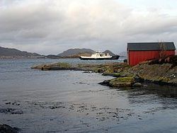
Vanylvsfjorden is a fjord in western Norway, on the border of Sogn og Fjordane and Møre og Romsdal counties. The 30-kilometre (19 mi) long fjord runs between the mainland of Vanylven Municipality and the Stad peninsula of Selje Municipality, with the islands of Sande Municipality lying in the mouth of the fjord. The inner part of the fjord branches into the Syltefjorden and Kjødepollen. The deepest part of the fjord reaches about 252 metres (827 ft) below sea level, just northeast of Borgundvåg.
Contents
- Vanylvsfjorden 2015 norway yamaha fzs 600 fazer
- Vanylvsfjorden norway 2015 part ii yamaha fzs 600 fazer
- References
There are settlements all around the shoreline of the fjord and on some of the islands at the mouth of the fjord. Some of the larger, more notable villages on the shore of the fjord include Fiskåbygd, Sylte, Slagnes, Åheim (all in Vanylven) and Leikanger and Borgundvåg (in Selje).
The Haugsholmen Lighthouse is located in the outer part of the fjord.