
State Kingdom of Denmark Postal code FO 497 Population 38 (2010) | Time zone GMT Climate Cfc | |
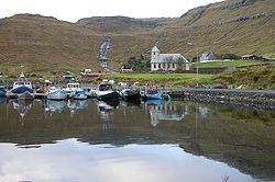 | ||
Selatrað (Danish: Selletræ) is a village on the west coast of the Faroese island Eysturoy in Sjóvar Municipality. The name Selatrað refers to a breeding place for seals.
Map of Selatra%C3%B0, Faroe Islands
The 2010 population was 38. Its postal code is FO 497. The village's church, the first in the archipelago made from concrete, was built in 1927. The third biggest plantation in the Faroe Islands is in Selatrað. It was severely damaged in a hurricane in 1988, destroying 2/3 of it. However the biggest trees (20m in height) survived.
Selatrað was once the parliamentary meeting place for the whole of Eysturoy.
References
Selatrað Wikipedia(Text) CC BY-SA