
 | ||
Sebakwe River or Zibagwe River is a river in Zimbabwe.
Contents
- Map of Sebakwe river Zimbabwe
- Background
- Little Sebakwe River
- Historical Operations
- Current Operations
- References
Map of Sebakwe river, Zimbabwe
Sebakwe River is located in the Midlands Province of Zimbabwe. It has a length 150 kilometres (93 mi) straight line from source to mouth. and is a tributary of Munyati River which it joins in Zhombe East at 18.6027°S 29.6188°E / -18.6027; 29.6188 (Sebakwe River mouth) .
Sebakwe River descends from the south-western heel of Mtoro Hill (elevation 1580m) north-east of Chivhu. It then flows south-westerly, east of Chivhu and west of The Range.
Background
The name Sebakwe is a distortion of the name Zibagwe meaning a very large maize plant or cob. The other version of the originality of the name say it derives from the name Chiwake meaning "that which is build up", referring to the barrier built during the rebellion".
Presently the name "Zibagwe" prevails. There is a legend orally transmitted that tells how the name Zibagwe came about. It says Zibagwe which is a ChiShona name for " a very large maize plant or cob" was given when local people visited to scavenge the camp that the European explorers had set for months. The said explorers had just left the camp to a destination further north into Mashonaland. Locals found a very large maize plant with very large cobs at the abandoned camp. Even though they had come treasure hunting for whatever the Whitemen could have left behind, no one touched the tempting maize plant because it was by the camp urinal, well fertilized by urine. The said maize plant was there for a long time, and because it was on the river bank, they called the river as "kuZibagwe" meaning "at the extra-large-maize plant".
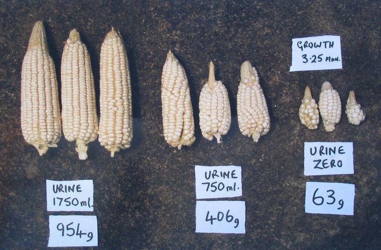
Though not officially stated it is thought that the Zibagwe "Urinal" Maize Plant encouraged the ecological experimental toilets project carried out in Zimbabwe a few years ago. A 3-year research project using diluted urine as fertilizer was conducted in Epworth, Harare (2008-2010) and the results were very positive. (The whole book shows how the application of diluted urine on plants can be very effective on plant growth.)
Little Sebakwe River
This article is about the main Sebakwe River that flows into the Munyati River.
There is another Sebakwe River known as Little Sebakwe River which has a length of 7.6 kilometres, and is entirely in Mashonaland East Province. Unlike the main Sebakwe River it flows easterly into Nyazvidzi River, the Save River drainage basin. Little Sebakwe passes north of Dombo hill (elevation 1455m) and south of Dowa hill (elevation 1386m) on its course towards Nyazvidzi River. It meets Nyazvidzi River south-east of St Kizito School in what was known as Eastdale Tribal Trust Land.
Historical Operations
Sebakwe River has a rich history.
It seems Kwekwe, then spelt Que Que was called Sebakwe before the assumption of the name Que Que.
In the sixteenth century a Portuguese explorer, Fernandes, camped on the banks of the Sebakwe River not{convert|5|mi|km} from Kwekwe.
King Lobengula had some reefs along Sebakwe River marked as his claims in September 1890
The land in which Sebakwe River passed through was known as Sebakwe District. A company that developed Gaika Mine in Que Que had 437 gold claims in the then Sebakwe district and all the water used was from the Sebakwe River.
In 1914 (some records say 1880) Fred Selous shot and killed a white rhino in this river and its skull was preserved. It is in the British Museum. The image name is "Sebakwe 1914"
Fredrick Selous was nearly killed by a leopard in the Sebakwe River.
Sebakwe River was boundary between Mashonaland and Matabeleland when Southern Rhodesia was still a two province nation. It was also a route for travelling from the east to the Salisbury-Bulawayo Road which was west of the Enkeldoorn and Fort Charter areas. Sebakwe River had also crossing places without bridges but a ferryboat, drawn across by a wheel which travelled along the cable like an aerial car.
Many early settlers found land along Sebakwe River unresistible.
Sebakwe River has always been a source of drinking and irrigation water. It even has weirs from the 19th century some created by wagon bridges.
Sebakwe River has alway been Kwekwe's life line from the onset. Que Que developed from mining compound townships for Gaika and Globe and Phoenix mines. Drinking Water for Gaika and G and P mines was ferried from Sebakwe River by ox wagon until G and P mine was granted water rights to pipeline water from the river 5.25 miles (8.45 km) away in 1898.
Sebakwe River also acted as the northern boundary of Kutanga Bombing Range in the then Rosedale Farming Area. The range was used by combat planes from Thornill Air Base which still owns it.
Current Operations
Sebakwe River supplies Munyati Power Station with water for boilers via a 23-kilometre long canal
The 266 mega litre Sebakwe Dam is across Sebakwe River, and it supplies Kwekwe, Sebakwe Recreational Park and Redcliff with water.
Sebakwe Recreational Park and the Sebakwe Black Rhino Trust Conservancy which does great work conserving wildlife. It is also dammed at Dutchman's Pool Dam is also on the Sebakwe River and a supplementary water source for Kwekwe.