
Crosses Great Bras d'Or Opened 1961 | Other name(s) Seal Island Bridge Total length 716 m | |
 | ||
Official name Great Bras d'Or Crossing Maintained by Nova Scotia Department of Transportation and Infrastructure Renewal Similar Canso Causeway, Grand Narrows Bridge, Fortress of Louisbourg, St Peters Canal, Through arch bridge | ||
Seal island bridge jump
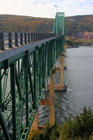
The Seal Island Bridge is a Canadian bridge located in Victoria County, Nova Scotia. It is the third longest bridge span in the province.
Contents
- Seal island bridge jump
- Map of Seal Island Bridge Victoria Subd B NS Canada
- Crossing seal island bridge
- Construction
- Controversy
- Deck replacement
- Awards
- References
Map of Seal Island Bridge, Victoria, Subd. B, NS, Canada
It is a through arch design and crosses the Great Bras d'Or channel of Bras d'Or Lake, connecting Boularderie Centre, Boularderie Island on the south side with New Harris, Cape Breton Island on the north side.
Crossing seal island bridge
Construction
Construction of the Seal Island Bridge began in 1960 as part of the Trans-Canada Highway project. The bridge, officially known as the Great Bras d'Or Crossing, was completed in 1961 at a cost of about $4,652,850. The construction of 23 kilometres (14 mi) of approach roads increased the total cost of the project to about $6-million. The bridge is a crucial link in the Trans Canada Highway between Sydney and Baddeck, carrying more than 7,500 vehicles a day in peak periods. The structure carries 2 traffic lanes of Highway 105 and was originally constructed with a pedestrian sidewalk on each side.
The bridge crosses part of the channel on a causeway connecting the north shore of the channel to Seal Island, a small wooded island. The structure consists of eight steel box truss spans; three simply supported 76.2 m (250 ft) approach spans, two simply-supported 76.2 m (250 ft) splay spans, and a three-span continuous main span that consists of two 106.68 m (350 ft) side spans and a 152.4 m (500 ft) centre arch span. The steel structure is supported on tall reinforced concrete piers, armoured with cut stone at the waterline.
Controversy
The location of the bridge had proven extremely controversial. It replaced two ferry services crossing the Great Bras d'Or; one at the northeastern end between New Campbellton-Big Bras d'Or, and the other at the southwestern end at Big Harbour-Ross Ferry.
For political reasons, it was decided to place the bridge halfway between the two ferry services on account of an outcry by communities fearing the loss of their transportation links. Unfortunately to do this required a massive modification to the Trans-Canada Highway route on the eastern slope of Kelly's Mountain (240 m (790 ft) high), resulting in a 180° "switchback".
A safer alternative to continue the highway further east on a gradual descent of Kelly's Mountain toward New Campbellton, crossing at the northern end of the Great Bras d'Or channel was rejected. Likewise, a route between Beinn Bhreagh and Kempt Head at the extreme southwestern end of the channel (much wider waterway but avoiding Kelly's Mountain altogether) was never considered. Numerous deaths at the switchback have occurred over the years.
Deck replacement
By 2001 it was found the existing cast-in-place concrete bridge deck was in poor condition. Forty years of wear and tear from traffic, and exposure to wind and salt spray, necessitated a major overhaul of the Seal Island Bridge. The road deck needed complete replacement, and the steel truss work needed reinforcement. Engineers had thoroughly inspected the rest of the bridge structure and found it to be sound and safe. A major deck replacement project was undertaken.
Over the next three years the original cast-in-place concrete bridge deck was removed and replaced using full-depth, precast, prestressed, half-deck width concrete panels. It was necessary to complete one lane at a time, starting with the south lane, leaving the other deck in place so the bridge could continue to be used for vehicular traffic. Construction was completed with minimal traffic disruptions and the bridge remained open to single lane traffic throughout construction, with the exception of three, six-hour overnight closures planned per week. This project added several decades to the useful life of the bridge.
The new high performance precast concrete deck system is much more durable than conventional systems since it is less permeable and crack-free under service load conditions. The deck system adopted is significantly lighter than a conventional cast-in-place concrete deck system. This has resulted in considerable savings in the amount of truss reinforcement required, while providing sufficient mass and stiffness for damping purposes. At the same time the guard rails (traffic barriers) were replaced over the entire length of the bridge, with the new guard rails set inside the main bridge trusses to better protect them from vehicle impact. Unfortunately this made the new bridge deck too narrow to retain the sidewalks so they were not replaced. This modification did result in wider traffic lanes. The overall cost of the bridge deck reconstruction was $15 million. There are now "No pedestrian traffic" signs on each end of the bridge.
Awards
On April 20, 2004 it was announced the Seal Island Bridge Reconstruction Project had won the Lieutenant Governor's Award for Engineering Excellence. The Department of Transportation and Public Works shared the honours with consultants CBCL Limited of Halifax for the major overhaul of the province's third largest bridge.