
 | ||
Drone flight scroby sands wind farm great yarmouth sea sand and dunes 30 06 2016
Scroby Sands is a sandbank or shoal, off the coast of Norfolk, England which runs near shore, north to south from Caister south towards Great Yarmouth. It has been the site of many shipwrecks.
Contents
- Drone flight scroby sands wind farm great yarmouth sea sand and dunes 30 06 2016
- Seals on scroby sands
- Description
- Wind farm
- Ships wrecked on Scroby Sands
- References
Seals on scroby sands
Description
Scroby Sands is 4 miles (6.4 km) from the coast and separated by channels from the adjacent Caister shoals, Cockle Shoals, Cross Sands, Corton and Holm Sands. Scroby sands is frequently shown on charts as having three components, named North Scroby, Middle Scroby and South Scroby.
It comprises a large group of shoals with Scroby Sands itself being the largest near shore sandbank in the group. It is deeper and narrower at its northern end and shallower and broader at its southern end.
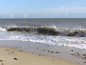
Wind farm
The sands are now clearly marked by the Wind turbines of Scroby Sands wind farm which were erected in 2003-4. The farm was commissioned by Powergen Renewables Offshore, a division of one of the UK's major electricity producing companies (now called E.ON UK), and is expected to produce up to a maximum of 60 megawatts of power, enough for 41,000 homes.
Ships wrecked on Scroby Sands
Some of the ships wrecked here include: