
Time zone CET (UTC+1) Area 18.62 km² Dialling code 0163 | Demonym(s) Scopellesi Elevation 659 m Local time Saturday 12:43 AM Postal code 13028 | |
 | ||
Frazioni Casa Pareti, Chioso, Frasso, Villabella Weather 9°C, Wind NW at 5 km/h, 77% Humidity | ||
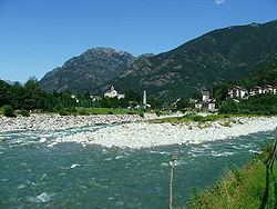
The Commune of Scopello (Italian: Comune di Scopello; population about 450) is located in the Valsesia region of the Italian Pennine Alps, in the Piedmontese Province of Vercelli. The municipality covers an area of 18.62 square kilometres (7.19 sq mi) and ranges in elevation from 640 to 1,930 metres (2,100 to 6,330 ft) above sea level. Its main centre of population, and the capoluogo of the commune, is the small town of Scopello which stands on the river Sesia at an elevation of 659 metres (2,162 ft).
Contents
Map of 13028 Scopello, Province of Vercelli, Italy
Other centres include Casa Pareti, Chioso, Frasso, Villabella, and Alpe di Mera., The last of these, as the name ‘Alpe’ suggests, once provided summer pasture for livestock. Today it is a winter ski resort.
Local government
Scopello belongs to the Comunità Montana Valsesia, a union of various communes in the Valsesia. The mayor is Paolo Ferraris, who stood on a local slate (lista civica), and was elected on 28 May 2006.
Neighbouring communes
Scopello borders Boccioleto, Campertogno, Caprile, Crevacuore, Guardabosone, Pettinengo, Pila, Piode, Scopa, Trivero, and Valle San Nicolao.