
Time zone CET/CEST (UTC+1/+2) Area 33.23 km² Local time Friday 5:08 PM Dialling code 035752 | Elevation 99 m (325 ft) Postal codes 01987 Postal code 01987 Population 6,344 (31 Dec 2008) | |
 | ||
Weather 12°C, Wind NE at 10 km/h, 45% Humidity | ||
Schwarzheide is a town in the Oberspreewald-Lausitz district, in southern Brandenburg, Germany. It is situated on the river Schwarze Elster, 11 km southwest of Senftenberg, 110 km south of Berlin and 40 km north of Dresden. The little river Pössnitz runs through the eastern part of Schwarzheide.
Contents
- Map of Schwarzheide Germany
- Neighbouring communities
- Districts
- History
- Political affinity
- Parliament
- Partnerships
- Culture and art
- Museums
- Historical monuments
- Buildings
- Natur and recreation areas
- Sports
- Transport
- Street
- Railway
- Companies
- Media
- Education
- Honored
- References
Map of Schwarzheide, Germany
Neighbouring communities
Immediate neighbors of the town are the towns Ruhland (south), Lauchhammer (west), Schipkau (north) and Senftenberg with the district Brieske (east).
Districts
Schwarzheide has the following districts
History
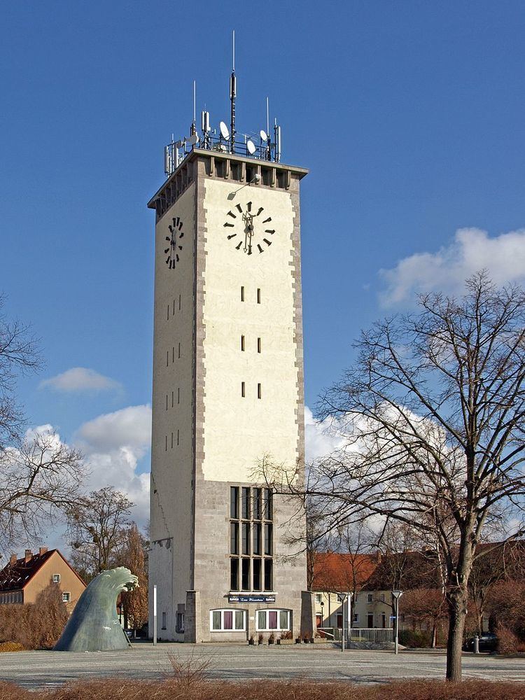
The town's landmark is the watertower. Today´s industrial town, Schwarzheide, was created on October 1, 1936, from the independent communities, Zschornegosda (today Schwarzheide-West) and Naundorf (now part of Schwarzheide-Ost). The name was translated from the Sorbian name, "Zschornegosda", (corny = black, gozd = heath, wood). The date of foundation of this community is unknown. Zschornegosda and Naundorf were founded in the 12th or the 13th century after the Christianization of the Sorbs.
The first written evidence of Naundorf (as Nuwendorff) came from a pledge deed from 1421. Zschornegosda was first written in 1449 (as Cschörnegast) in feudal deed of Duke Frederick II, Elector of Saxony. Naundorf is a typical street village. Zschornegosda is a rotunde called okolnica. The chapel was on the highest point of a sandy knoll.
The development of both villages was retarded by wars, fires, and epidemics. Until the 18th century, the villages had no more than 100 inhabitants.
In 1780, the discovery of lignite coal west of Zschornegosda in Bockwitz lead to mining and the foundation of briquette factories (Ferdinand, Victoria, Victoria II). The river, Schwarze Elster, was drained and converted to a canal, so it was no longer possible to live from fishing. Highway A13 was built in 1936.
When the village's population reached eight-thousand inhabitants, the village became a town on January 11, 1967.
After 1990, Synthesewerk Schwarzheide became a part of BASF AG, which manufactures polyurethane.
Political affinity
The river, Schwarze Elster, forms the border between lower and upper Lusatia. From 1635, both Zschornegosda and Naundorf were part of Saxony. In 1815 both villages came to Prussia because of the Congress of Vienna. Between 1818 and 1952, Zschornegosda and Naundorf were part of Kreis Calau. From 1952 to 1990, Schwarzheide was a part of Kreis Senftenberg in Bezirk Cottbus.
In 1990, town was annexed to Brandenburg, and, on December 6, 1993, to Oberspreewald-Lausitz.
Parliament
The town parliament of Schwarzheide comprises the mayor and 18 members.
The turnout stood at 56,9 percent.
Partnerships
Culture and art
Symbol is the 36 m high watertower built in 1943/44 by French prisoners of war.Lutherkirche from 1754 is also located in the center. The oldest nightclub in eastern Germany is Freizeitpark Wandelhof and there is also a cinema with four sals and 650 places.
Museums
Historical monuments
Buildings
Natur and recreation areas
Pine forests, lakes, meadows, and pastures surround Schwarzheide. The Lusatian Lake District and Spreewald are also near Schwarzheide.
Sports
Eurospeedway Lausitz is near.
Transport
federal highway 13 Bundesautobahn 13 from Berlin to Dresden, in south B 169. There is a rail way point in Schwarzheide-Ost.
Street
A 13 (E 55): Berlin–Dresden (Anschlussstelle (16) Schwarzheide and Anschlussstelle (17) Ruhland)
Railway
RE 18: Falkenberg (Elster)–Bad Liebenwerda–Lauchhammer–Ruhland–Schwarzheide-Ost–Senftenberg–Drebkau–Cottbus
Companies
The largest employer is BASF Schwarzheide GmbH. Other companies include Fränkische Rohrwerke and PeinigerRöRo.
Media
Education
In Schwarzheide exist a secondary school (Schwarzheide-Wandelhof), a high school(Emil-Fischer), a division of Oberstufenzentrums Lausitz (OSZ) to train laboratory technicians and chemistss, and a music school.