
Population 2,403 Local time Friday 10:49 AM | OS grid reference SE 37766 37254 Sovereign state United Kingdom | |
 | ||
Weather 9°C, Wind NE at 14 km/h, 68% Humidity | ||
Scholes is a village between Leeds and Barwick-in-Elmet, West Yorkshire, England. It is part of the civil parish of Barwick in Elmet and Scholes in the City of Leeds. It is sometimes known as Scholes-in-Elmet to distinguish it from the Scholes, Holme Valley and Scholes, Cleckheaton in Kirklees, West Yorkshire, by analogy with Barwick-in-Elmet and Sherburn-in-Elmet. Its name is a plural of Old Norse skáli = "temporary shed". In 2001, its population was 2,403.
Contents
Map of Scholes, Leeds, UK
History
In the 1800s, Colonel Frederick Trench-Gascoigne (of Parlington Hall, Aberford) owned and rented out a large number of houses, mines, woodlands and farming land in the areas of Scholes, Swarcliffe, Barnbow, Garforth, Barwick-in-Elmet, Cross Gates, and Whinmoor.
In the mid-1880s, a previous occupant of the Seacroft windmill, Isaac Chippindale, started the Scholes Brick and Tile Works on Wood Lane, on the border to Swarcliffe. The company's quarry produced high-quality bricks with which many houses in the surrounding area were built. Its kilns and house were demolished in the early 1980s, leaving two small fishing lakes, but is still known as "Chippy's Quarry".
Amenities
Scholes has several shops including a convenience store and off-licence, two pubs, a library and two churches. The nearest commercial centres are in Seacroft and Cross Gates. The Seacroft Green shopping centre contains amongst other shops a large Tesco supermarket, while the Cross Gates Shopping Centre (formerly an Arndale Centre) contains many high street shops. Other nearby commercial centres include Garforth and Wetherby.
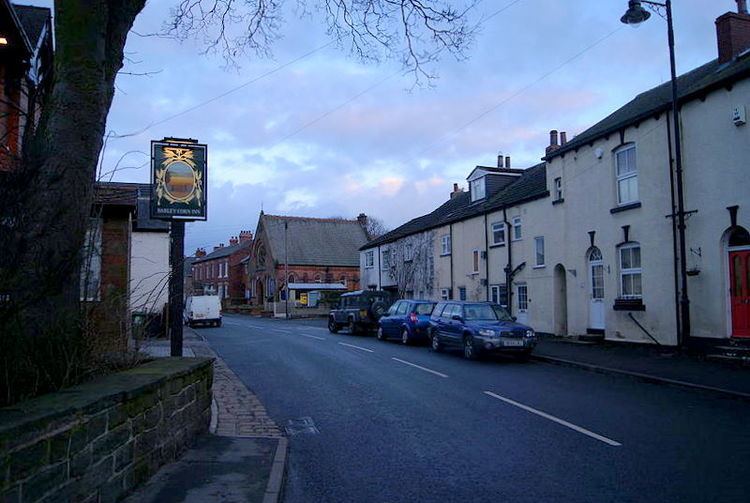
The Barley Corn is a historic Samuel Smiths pub on Main Street, while the former railway station on Station Road (The Buffers) has been converted into a pub and restaurant.
Transport
Scholes lies close to the Leeds Outer Ring Road, the A64 and the M1. Opened on 1 May 1876, a rail connection owned by LNER (London and North Eastern Railway) ran past the eastern border of Swarcliffe and Stanks, which was a part of the Cross Gates to Wetherby line. In 1965, services were withdrawn as part of the Beeching Axe; an informal name for the British Government's attempt to reduce the cost of running British Railways in the 1960s. Local bus services are 64 and 11,provided by First Leeds, . The nearest international airport is Leeds Bradford Airport, which is 12.4 miles (20 km).
Comparison
Scholes is in the LS15 postcode area.
Climate
The climate in Scholes is moderate.