
Max. length 2.3 km (1.4 mi) Surface area 2.241 km (0.865 sq mi) Surface elevation 777 m Width 1.3 km Mean depth 20 m | Basin countries Germany Max. width 1.3 km (0.81 mi) Average depth 20 m (66 ft) Area 224 ha Length 2.3 km | |
 | ||
Similar Alps, Spitzingsee, Burg Hohenwaldeck, Brecherspitz, Roßkopf | ||
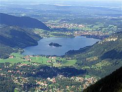
Schliersee is a natural lake in Upper Bavaria in the Bavarian Alps. It is located next to the small town of Schliersee in the Miesbach district.
Map of Schliersee, 83727 Schliersee, Germany
The lake has a surface of 2.241 square kilometres (0.865 sq mi) at an elevation of 777 metres (2,549 ft) AMSL, expanding 2.3 kilometres (1.4 mi) by 1.3 kilometres (0.81 mi) maximum. The average depth is 20 metres (66 ft) The maximum depth is 40 metres (130 ft). The only island is Wörth island, located almost in the middle of the lake.
The lake is named for the monastery Kloster Schliersee ("Sliersee"), established in 779 at Kirchbichl nearby Westenhofen.
References
Schliersee (lake) Wikipedia(Text) CC BY-SA