
Elevation 720 m (2,360 ft) Area 115 km² Dialling code 0473 | Time zone CET (UTC+1) Local time Friday 8:36 AM Postal code 39028 | |
 | ||
Frazioni Göflan (Covelano), Kortsch (Corces), Nördersberg (Montetramontana), Sonnenberg (Montemezzodì), Vetzan (Vezzano) Demonym(s) German: SchlanderserItalian: Silandresi Weather 8°C, Wind E at 3 km/h, 81% Humidity Region Trentino-Alto Adige/South Tyrol | ||
Schlonders isch onders schlanders ist anders das video zum song
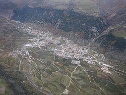
Schlanders ( [ˈʃlandɐs]; Italian: Silandro [siˈlandro]) is a comune (municipality) in South Tyrol in northern Italy, located about 50 kilometres (31 mi) west of the city of Bolzano.
Contents
- Schlonders isch onders schlanders ist anders das video zum song
- Map of 39028 Silandro Province of Bolzano South Tyrol Italy
- Schlanders silandro latsch laces kastelbell castelbello tschars ciares ss38 s dtirol italien 8 4 15
- Overview
- Linguistic distribution
- Twin towns
- References
Map of 39028 Silandro Province of Bolzano - South Tyrol, Italy
Schlanders silandro latsch laces kastelbell castelbello tschars ciares ss38 s dtirol italien 8 4 15
Overview
Schlanders borders the following municipalities: Latsch, Laas, Mals, Martell, Schnals.
Schlanders is well-known because of its church tower, 92 metres (302 ft) high, which is also the highest in South Tyrol. Another attraction is the renovated castle, which now serves as a civic hall (including a public library).
The locality was mentioned for the first time officially on 13 June 1077 in a deed of donation, where the Holy Roman Emperor Henry IV. handed over the town to Altwin, the Bishop of Brixen.
Linguistic distribution
According to the 2011 census, 94.66% of the population speak German, 5.19% Italian and 0.14% Ladin as first language.