
Listing Marilyn, Hewitt Elevation 678 m Province Ulster | OSI/OSNI grid H618973 Prominence 657 m Parent range Sperrins | |
 | ||
Topo map OSNI Discoverer Series 13 The Sperrins (1:50000), OSNI Activity Map Sperrins (1:25000) Similar Slieve Gallion, Mullagh - County Londonderry, Benbradagh, Mullaghcarn, Slieve Snaght | ||
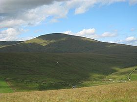
Sawel Mountain (from Irish: Samhail Phite Méabha, meaning "likeness to Méabh's vulva") is the highest peak in the Sperrin Mountains, and the 8th highest in Northern Ireland. It is also the highest mountain in Northern Ireland outside of the Mourne Mountain range located in County Down. To the north of Sawel is County Londonderry, and to the south, County Tyrone. The summit is 678 metres (2,224 ft) high and is composed of crystalline limestone. Around the peak, there is "montane heathland", with plant life including heather, bilberries and cowberries, although this is being damaged by hillwalking and grazing. Sawel is the source of the River Faughan, a 29 miles (47 km) long tributary of the River Foyle.
Map of Sawel Mountain, Londonderry, UK
The Irish name of the mountain is a reference to a glen or hollow on the side of Sawel. It was also historically called Slieve Sawel, 'Slieve' being an anglicization of Sliabh ("mountain").