
Area rank 264 in Norway Area 321 km² Administrative center Akkerhaugen | County Telemark Administrative centre Akkerhaugen Demonym(s) Sauhering Population 4,351 (2004) | |
 | ||
Sauherad is a municipality in Telemark county, Norway. It is part of the traditional region of Midt-Telemark. The administrative centre of the municipality is the village of Akkerhaugen. The municipality borders Kongsberg, Skien, Nome, Bø, and Notodden.
Contents
- Map of Sauherad Norway
- Name
- Coat of arms
- Transportation
- Notable residents
- Sauherad church
- Sister cities
- References
Map of Sauherad, Norway
The parish of Søfde (later spelled Saude, then Sauherad) was established as a municipality on 1 January 1838 (see formannskapsdistrikt). The area of Luksefjell was transferred from Sauherad to Gjerpen in 1847.
Name
The municipality (originally the parish) is named after the old Sauar farm (Old Norse: Sauðar), since the first church was built here. The name is the plural form of sauðr which means "spring" or "issue of water". The meaning of the combination Sauherad (Old Norse: Sauðaherað) is "the district (herað) of Sauðar". Prior to 1918, the name was written "Saude" or (before 1862) "Søfde".
Coat-of-arms
The coat-of-arms is from modern times. They were granted in 1989. The arms show a gold-colored apple tree on a blue background. It was designed by Halvor Holtskog.
Transportation
Notable residents
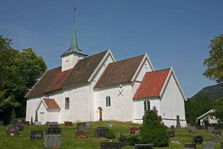
Sauherad church
Sauherad church (Sauherad kirke) dates from the medieval era. The church was built between 1150 and 1250. The edifice is of stone and has 260 seats. The church is built in Romanesque style. On the ridge, in the middle of the gable roof, sits a turret. The church bells are from 1441. The altarpiece from 1663 is of Renaissance style. In 1781 the building was extended westward. In 1830 the church received a new interior. The frescoes in the nave were uncovered and restore during the 1940s and 1950s.
Sister cities
The following cities are twinned with Sauherad: