
Website Official website | Tehsils 07 Area 7,502 km² | |
 | ||
Colleges and Universities Mahatma Gandhi Chitrakoot Gramoday Vishwavidyalaya, AKS University Points of interest Maa Sharda Temple M, White Tiger Safari - Mukundp, Hanuman Dhara, Sita Rasoi, Sphatik Shila | ||
Satna District (सतना)(Cement City), was formed in 1948, is a district of Madhya Pradesh state in central India. The town of Satna is the district headquarters. The district has an area of 7,502 km², and a population of 768,648 (2011 census), 20.63% of which was urban. The district has a population density of 249 persons per km².
Contents
- Map of Satna Madhya Pradesh
- Abp news special l ground zero report from satna district where 10 people killed in temple stampede
- Geography
- History
- Economy
- Demographics
- Languages
- Tourist attractions
- Chitrakoot
- Maihar
- Birsinghpur
- Griddhraj Parvat
- Bharhut
- Other places
- See also
- References
Map of Satna, Madhya Pradesh
Abp news special l ground zero report from satna district where 10 people killed in temple stampede
Geography
Satna district has Uttar Pradesh on the north, Rewa on the east, Shahdol on the southwest, Umaria and Katni districts on the south, and Panna on the west. The district is part of Rewa Division. The district is divided into the tehsils of Amarpatan, Maihar, Nagod, Uchehara, Birsinghpur, Koter, Majhgawan, Ramnagar, Rampur baghelan & Sohawal. Satna town is situated in Sohawal tehsil.
History
Satna district is part of the Baghelkhand region, a very large portion of which was ruled by the Rewa. A small portion of the western region was ruled by feudatory chiefs under the British. There were eleven such states, namely Maihar, Nagod State, Sohawal, Kothi, Jaso, Baraundha and the five Chaube Jagirs of Chanpurwa, Pahra, Taraon, Bhaisunda and Kamta-Rajaula.
The early Buddhist books, the Mahabharata etc. link the Baghelkhand tract with rulers of the Haihaya, Kalchuri or Chedi clan, who gained sufficient importance in the 3rd century CE. They had their capital at Mahishmati (identified by some with Maheshwar in Khargone District), from where they seem to have been driven eastwards. They had acquired the fort of Kalinjara (a few miles beyond the border of the district, in Uttar Pradesh), and with that as base, they extended their dominious over Baghelkhand. During the 4th and 5th centuries, the Gupta dynasty held sway over the area. The feudatory chiefs of Uchchhakalpa (Unchehra in Nagod tehsil) and the Parivrajakas of Kot (in Nagod tehsil) held their own. The chief stronghold of the Chedi clan was Kalinjar, and their proudest title was Kalanjaradhishwara (Lord of Kalanjar). The Kalchuris received their first blow at the hand of Chandel chief Yashovarmma (925-55), who seized the fort of Kalinjar and the tract surrounding it. The Kalchuris were still a powerful tribe and continued to hold most of their possessions until the 12th century.
The chiefs of Rewas were Baghel Rajputs descended from the Solanki clan. Vyaghra Deo, brother of the ruler of Gujarat, made his way into northern India about the middle of the 13th century and obtained the fort of Marpha, 18 miles north-east of Kalinjar. His son Karandeo married a Kalchuri (Haihaya) princess of Mandla and received in dowry the fort of Bandhogarh (now in the tehsil of the same name in Shahdol district), which, until its destruction in 1597 by Akbar was the Baghel capital.
In 1298, when Ulugh Khan drove the last Baghel ruler of Gujarat from his kingdom. It caused a considerable migration of the Baghels to Bandhogarh. Until the 15th century the Baghels of Bandhogarh were engaged in extending their possessions and escaped the attention of the Delhi kings. In 1498-9, Sikandar Lodi failed in his attempt to take the fort of Bandhogarh. The Baghel king Ramchandra (1555–92), was a contemporary of Akbar. After the death of Birdhabra, Ramchandra's son, a minor named Vikramaditya acceded to the throne of Bandhogarh. His accession gave rise to disturbances. Akbar intervened and captured and dismantled the Bandhogarh fort in 1597 after a seize of eight months. It is after this that the town of Rewa started gaining in importance.
In 1803, after the treaty of Bassein, the British made overtures of alliance to the ruler of Rewa, but the latter rejected them. In 1812, during the time of Raja Jaisingh (1809–35), a body of Pindaris raided Mirzapur from Rewa territory. Upon this Jaisingh was called upon to accede to a treaty, in which he acknowledged the protection of the British Government, and agreed to refer all disputes with neighbouring chiefs to their arbitration and to allow British troops to march through or be cantoned in his territories. At the mutiny of 1857, Maharaja Raghuraj Singh helped the British in quelling the uprisings in the neighbouring Mandla and Jabalpur district, and in Nagod which is now a part of Satna district. For this, the king was rewarded by restoration to him of the Sohagpur (Shahdol) and Amarkantak parganas, which had been seized by the Marathas in the beginning of the century. The rulers of Rewa State bore the title of 'His Highness' and "Maharaja" and received a salute of 17 guns. Most of the Raghuraj Nagar and entire Amarpatan tehsil of the present Satna district were in the Rewa State prior to the formation of Vindhya Pradesh.
Economy
In 2006 the Ministry of Panchayati Raj named Satna one of the country's 250 most backward districts (out of a total of 640). It is one of the 24 districts in Madhya Pradesh currently receiving funds from the Backward Regions Grant Fund Programme (BRGF).
Demographics
According to the 2011 census Satna District has a population of 2,228,619, roughly equal to the nation of Latvia or the US state of New Mexico. This gives it a ranking of 203rd in India (out of a total of 640). The district has a population density of 297 inhabitants per square kilometre (770/sq mi) . Its population growth rate over the decade 2001-2011 was 19.17%. Satna has a sex ratio of 927 females for every 1000 males, and a literacy rate of 73.79%.
In the 2001 census, Satna district had a total population of 1,868,648, out of which 970,114were males and 898,534 were females. Decadal growth in 1991-2001 was 27.52. Sex ratio was 926. Density of population was 249 / km2.
Languages
Among the languages spoken in Satna is Bagheli, which has a lexical similarity of 72-91% with Hindi (compared to 60% for German and English) and is spoken by about 7,800,000 people in Bagelkhand.
Tourist attractions
Satna district has major sites of archeological, religious and tourist interest.
Chitrakoot
Chitrakuta is a town of religious, cultural, historical and archaeological importance, situated in the Satna district in the Bundelkhand region of Madhya Pradesh; bordering the Chitrakoot district is Uttar Pradesh, India. It is known for numerous temples and sites mentioned in Hindu mythology. Chitrakuta’s spiritual legacy stretches back to legendary ages. It was in these deep forests that Rama, Sita and his brother Lakshmana spent eleven and half years of their fourteen years of exile. The great sage Atri, Sati Anusuya, Dattatreya, Maharshi Markandeya, Sarbhanga, Sutikshna and various other sages, seers, devotees and thinkers meditated here. The principal trinity of the Hindu pantheon, Brahma, Vishnu and Mahesh, took their incarnations here.
Maihar
Maihar has a temple by the name of Sharda Devi situated on the top of Trikuta hill about 5 km from the center of the town. This temple is known for its stairway of more than 1,000 steps. Millions of devotees throng to the temple throughout the year. There is a 3.1 mn tn cement factory near Maihar (Maihar Cement Factory) which provides an industrial touch to the holy place. The factory complex and the township are situated at Sarlanagar about 8 km away from Maihar town on the Maihar-Dhanwahi Road. Two new cement factories, KJS Cement and Reliance Cement, are also setting up their cement factories here.
NTPC, the power giant of India, is setting up a thermal plant at Barethi in Maihar.
Birsinghpur
Birsinghpur has a temple by the name of old shiv temple situated in main market 0.5 km from Satna Birsinghpur road. Millions of devotees throng to the temple throughout the year.
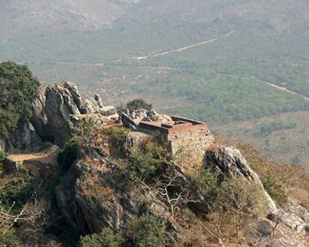
Griddhraj Parvat
Griddhraj Parvat (Hindi: गृद्घराज पर्वत, the hill of vultures), is a hill of religious, archeological and ecological importance situated in Devrajnagar village of tehsil Ramnagar in Satna district. It is located 8 km from the town of Ramnagar. Griddhraj Parvat is of great religious importance in Hindu mythology. It was mentioned in Skanda Purana as ‘Griddhanchal Parvat’. It is believed to be the birthplace of ‘Sampati’, the brother of Griddhraj ‘Jatayu’ mentioned in Ramayana. The poet Kalidas mentions this place as the most sacred in his book ‘Griddharaj Mahatmya’ (Narad Uvach). He wrote that a dip in the Manasi Ganga River originating from Griddhraj Parvat, at an altitude of 2,354 feet, absolves all kinds of sins. Sons of Brahma and then goddess Parvati first saw this hill. It is also mentioned in Shiva Samhita. Chinese traveller Fa-hien visited this place and mentioned it.
Bharhut
Also in Satna district is the ancient city of Bharhut, a center of Buddhist culture, whose archeological treasures have been gifted to the major museums in the country and the world. The Bharhut stupa may have been established by the Maurya king Ashoka in the 3rd century BCE, but many works of art were apparently added during the Shunga period, with many friezes from the 2nd century BCE.
Other places
Apart from tourism, Satna also hosts a number of industries, primarily concrete and steel. Satna is also viewed as one of the better commercial towns of eastern Madhya Pradesh.