
Demonym(s) Satarkar Area 22.42 km² Population 326,765 (2011) | Time zone IST (UTC+5:30) Elevation 742 m Local time Thursday 8:16 AM | |
 | ||
Weather 27°C, Wind N at 5 km/h, 38% Humidity Points of interest Ajinkyatara Fort, Rajwada, Natraj Mandir - Uttar Chi, Koteshwar Mandir, Ajinkyatara | ||
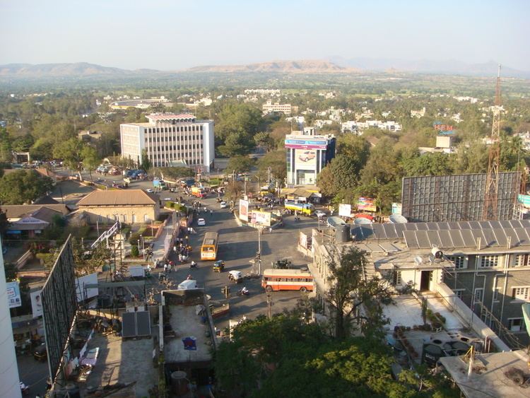
Satara ( pronunciation is a city located in the Satara District of Maharashtra state of India, near the confluence of the river Krishna and its tributary river Venna. The city was established in the 16th century and was the seat of Raja of Satara Chhatrapati Shahu. It is the headquarters of Satara Tahsil, as well as Satara District. The city gets the name from Seven-forts(Sat-Tara) which are close to the city.Satara is well known for its sweet: kandi pedhe.
Contents
- Map of Satara Maharashtra
- Medieval
- Features
- How to visit
- Geography
- Climate
- Tourism
- Demographics
- Transport
- References
Map of Satara, Maharashtra
Medieval
The first Muslim invasion of the Deccan took place in 1296. In 1636 the Nizam Shahi dynasty came to an end. In 1663 Shivaji conquered Parali and Satara fort. After death of Shivaji, Shahu Shivaji, Heir Apparent to Maratha Kingdom, captured by Mughals when he was only seven years old, remained their prisoner till the death of his father in 1700. The Dowager Maharani Tarabai proclaimed his younger half-brother, and her son, Shahu Sambhaji as Chhatrapati Maharaj under her regency. Mughals released Shahu with some conditions in 1707, so that Marathas would face an internal war for the throne. Shahu returned to Maratha empire and claimed his inheritance. Aurangzeb's son Muhammad Azam Shah conquered Satara fort (Ajinkyatara) after a 6-month siege, later won by Parshuram Pratinidhi in 1706. In 1708 Chattrapati Shahu, the son of Chhatrapati Sambhaji, was crowned on the Satara fort. The direct descendents of Raja Shivaji continue to live in Satara. Udayanraje Bhonsle is the 13th descendent of Shivaji Maharaj.Dundle is the Sardar Of Chhatrpati Shivaji Maharaj.
Features
How to visit
Satara can be reached by road, train or by air. It is about 250 km from Mumbai. There are busses starting at 9 AM in the Morning. Train services from CST to Kolhapur via Satara. Also available are S.T buses from Borivali, Dadar, Mumbai central, Bhayandar, Thane to Satara.
Geography
Satara is located at 17.68°N 73.98°E / 17.68; 73.98. Satara city is surrounded by Seven mountains.
It is located on National Highway 4, between Karad and Khandala.
Climate
Satara city have Pleasant climate all around year due to mountains surrounding City.Summers are not too hot and winters are not too cold.Satara city receives Moderate rainfall around 1200 to 1500 mm all around year.
Tourism
The famous tourist points near Satara City are:
Demographics
As of 2011 India census, Satara had a population of 120,079; males constituted 52% of the population and females 48%. Satara has an average literacy rate of 80%, higher than the national average of 74%: male literacy is 84%, and female literacy is 76%. In Satara, 10% of the population is under 6 years of age. Marathi is the native and most widely spoken language, although English, Kannada and Gujarati are also spoken.
Maharashtra state's sex ratio is 883 girls per 1000 boys, and Satara fares worse still at 881, in spite of the high level of literacy. The population of Satara has crossed the municipal limits and actual urban agloromation population 326,765.
Transport
Satara city is well connected with the rest of Maharashtra by road and rail. National Highway 4 running between Mumbai and Chennai passes through Satara. A bypass was constructed in the 1990s to avoid traffic congestion in the city. NH4,ma part of the Golden Quadrilateral, has been fully converted to a 4-lane divided highway while the stretch between Pune and Satara has been upgraded to 6-lane. National Highway 665 Starts from Satara,Satara-Akluj-Latur Highway connects Satara city to Latur,it passes through koregaon,pusegaon,mhaswad,Akluj,Tembhurni ,Murud.It is will be also a 4 lane highway,work is going to start soon.
State Highway 58 connects Satara with Mahabaleshwar and Solapur.Satara railway station lies on the Pune-Miraj line of the Central Railways and is administered by the Pune Railway Division. The railway station is located a small distance east of the city and is served by several express trains. Sahyadri Express, Koyna Express, Mahalaxmi Express, Maharashtra Express, Goa Express are daily trains that have stops at Satara.