
South end: Hwy 26 in the MeotaRM Length 45.4 km | Rural
municipalities: Meota, Parkdale Province Saskatchewan | |
 | ||
North end: Hwy 3 in the Parkdale RM | ||
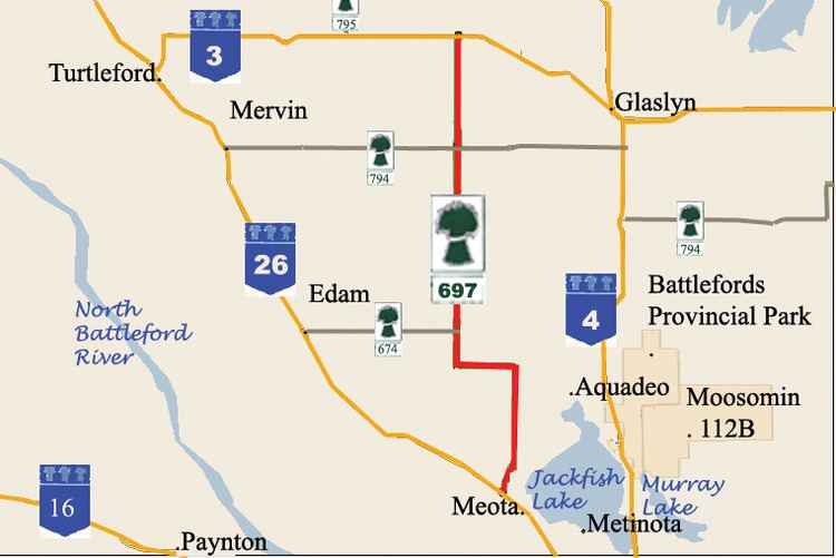
Saskatchewan Highway 697 connects Saskatchewan Highway 26 in the Meota rural municipality (RM) to Saskatchewan Highway 3 in the Parkdale RM. The length of Highway 697 is 45.4 kilometres (28.2 mi) and extends north, in the north western area of Saskatchewan west of North Battleford. There are no communities along Highway 697.
Contents
Map of SK-697, Saskatchewan, Canada
Rural municipalities
The rural municipality (RM) of Meota Number 468 number 468 has a population of 984 residents who are mainly farmers. The retail sector is the next highest employer in this area catering to the tourism sector followed by educational services. Hunting for waterfowl in this region is popular. A Federal Bird Sanctuary was established in the region in 1962 around Scentgrass Lake. Fishing is enjoyed on Jackfish Lake and in the Battlefords Provincial Park which is on the eastern banks of Jackfish Lake. In this region there are erected oil wells in the Meota Lloydminster Sand Pool. The RM is located on a parkland transition area in Jackfish country. The Local Improvement District was established to monitor civic affairs in 1907. In 1909, the RM of Meota was incorporated. Parkdale Number 98 has a population of 711 residents, with the majority of these employed in the agricultural sector. The next highest employer is education followed by industry. Parkdale RM was established in 1913, preceded by the Local Improvement District which handled civic affairs for three years prior to this. Seasonal visitations increase the population in the resort area of this region. 6 kilometres (3.7 mi) west of Glasylyn is the Little Loon Regional Park in a boreal forest transition area.
The area belongs to Battlefords Regional Economic Development Authority which has a mandate of creating jobs and employment opportunities in the area enhancing its economic sector.
Travel Route
Highway 697 begins in a northerly direction at the intersection with Highway 26. To the west along Highway 26 is the town of Vawn, and to the east along highway 26 is the town of Meota, Saskatchewan. The beginning terminus circumnavigates around the western shoreline of Jackfish Lake. At Km 11.3, Highway 697 turns west sharply.At Km 16.1, Highway 697 then returns to its northerly routing. At Km 19.3 the Highway meets with the junction with Highway 674. Highway 674 only extends in a westerly direction providing access to the town of Edam. At Km 35.5, Highway 697 intersects with Highway 794. Travel west on Highway 794 provides access to the town of Mervin, travel east on Highway 794 provides joins Saskatchewan Highway 4 south of the town of Glaslyn. At Km 45.4, Highway 697 ends at Highway 3. To the north west of the terminal junction is the town of Livelong, to the south east along Highway 3 is the town of Glaslyn.