
Country United States Time zone EST (UTC-5) Local time Wednesday 3:03 PM | County Coos Population 0 (2000) | |
 | ||
Weather -22°C, Wind W at 116 km/h, 95% Humidity Points of interest Mount Washington, Mount Washington State Park, Lakes of the Clouds, Presidential Range, Tuckerman Ravine | ||
Sargent's Purchase is a township located in Coos County, New Hampshire, United States. As of the 2010 census, the purchase had a total population of 3.
Contents
Map of Sargent's Purchase, NH 03846, USA
In New Hampshire, locations, grants, townships (which are different from towns), and purchases are unincorporated portions of a county which are not part of any town or city and have limited self-government (if any, as many are uninhabited).
History
The first known explorer to have stepped foot in what is now known as Sargent’s Purchase was Darby Field, who claimed to have made the first ascent of Mount Washington in 1642. Sargent’s Purchase was granted to Jacob Sargent and others on May 31, 1832. In May 1866, Sylvester Marsh of Campton, New Hampshire, began construction of the Mount Washington Cog Railway, primarily in Thompson and Meserve's Purchase, but the uppermost half mile being within Sargent's Purchase. The Cog Railway was completed in 1869.
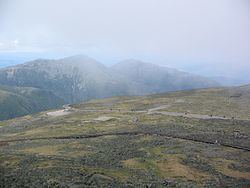
Geography
According to the United States Census Bureau, the township has a total area of 25.9 square miles (67 km2), of which 0.04% is water.
Mount Washington, with an elevation of 6,288 feet (1,917 m) above sea level, the highest mountain in New England, is located in Sargent's Purchase. Other notable summits within the purchase include Mount Monroe, at 5,380 feet (1,640 m); Mount Isolation, at 4,004 feet (1,220 m); and Stairs Mountain, at 3,468 feet (1,057 m). The Ammonoosuc River has its headwaters in the township.
Demographics
As of the census of 2010, there were 3 people living in the township.