
Arabic صرعة Also spelled Surah Palestine grid 148/131 | Name meaning from Zoreah Date of depopulation 18 July 1948 | |
 | ||
Sar'a (Arabic: صرعة), was a Palestinian Arab village located 25 km west of Jerusalem, depopulated in the 1948 war.
Contents
History
The Canaanites referred to Sar'a by the name of Sur'a or Zorah, mentioned in the Amarna letters, subsequently it was a Danite place, while the Romans called it Sarea. Sar'a had two shrines, one of which is still standing. The first belongs to al-Nabi Samat, and the other for an unknown individual. The village also has several khirbas including Khirbat al-Tahuna, where the ruins of a building constructed of ashlars (squared stone masonry) and the foundations of other buildings.
Ottoman era
Incorporated into the Ottoman Empire in 1517 with the rest of Palestine, Saris appears in the 1596 tax records as a village in the nahiya (subdistrict) of al-Ramla under the liwa' (district) of Gaza with a population of 94. The villagers paid taxes on a number of crops, including wheat, barley, olives, goats and beehives.
In 1838 Edward Robinson reported that the village belonged to the "Keis" faction, together with Laham Sheiks, of Bayt 'Itab.
In 1863 Victor Guérin found it to be a village with some three hundred inhabitants. An Ottoman village list of about 1870 indicated 21 houses and a population of 59, though the population count included only men.
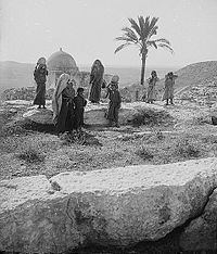
In 1883, the Palestine Exploration Fund's Survey of Western Palestine (SWP) described it as a moderate sized village, standing on a low hill. A domed maqam, Neby Samat, stood to the south. SWP further noted "Caves exist here, and ruined tombs; one was a square chamber without loculi; another, a large tomb with a rock pillar, but now much broken, and the plan of the original form destroyed. This tomb is close to the Mukam of Neby Samit—a domed chamber, with an outer chamber to the west, and a door to the north, on which side is a courtyard, with a palm tree. The chamber has a mihrab, and by it are green rags, said to be the Prophet's clothes. In the court are two Arab graves. To the west are several kokim tombs full of bones and skulls. Other caves, cisterns, and a wine-press, north of the Mukam, were observed." Sheikh Samit, or Samat, was said to have been the brother of Shemshun el Jabar, whose Neby was at Ishwa.
J. Geikie described the shrine in the 1880s: "A mukam, or shrine, of a Mussulman saint stands on the south side of the village; a low square building of stone, with a humble dome and a small court, within an old stone wall, at the side. You enter the yard through a small door in this wall, up two or three steps, but beyond the bare walls, and a solitary palm-tree, twice the height of the wall, there is nothing to see. Sheikh Samat, whoever he was, lies solitary enough and well forgotten in his airy sepulchre, but the whitewash covering his resting-place marks a custom which is universal with Mussulman tombs of this kind."
British Mandate era
In the 1922 census of Palestine conducted by the British Mandate authorities, Sara'a had a population 205, all Muslims, increasing in the 1931 census to 271, still all Muslims, in 65 houses.
In 1945 the population of Saris was 340, all Muslims, who owned 4,967 dunams of land according to an official land and population survey. Of the land, 194 dunams were plantations and irrigable land and 2,979 were for cereals, while 16 dunams were built-up (urban) land.
1948 and afterward
Sar'a was captured by Israel's Harel Brigade on July 13–14, 1948, during the offensive Operation Dani in the 1948 Arab-Israeli War. Many of the inhabitants had already fled, as the village had been on the front lines since April. Those who had remained fled when the mortar barrages from the approaching Harel columns began; the few that stayed throughout the assault were later expelled. The village's inhabitants fled the village towards various West Bank refugee camps, including Qalandiya.
The Israeli locality of Tarum was established on the north-eastern part of village land in 1950, while Tzora was established about 2 km southwest of the site, on land belonging to Dayr Aban.
According to the Palestinian historian Walid Khalidi, the village remaining structures on the village land were in 1992:
Stone rubble and iron girders are strewn among the trees on the site. A flat stone, surrounded by debris and inscribed with Arabic verses from the Qur'an, bears the date A.H. 1355 (1936). On the western edge of the site stands a shrine containing the tombs of two local religious teachers. A valley to the northeast is covered with fig, almond, and cypress trees.