
Barangays Local time Wednesday 10:40 AM | Area 676 km² | |
 | ||
Region National Capital Region Congressional districts Part of the 6th district of Manila Weather 31°C, Wind SE at 13 km/h, 63% Humidity Colleges and Universities Polytechnic University of the Phil, De Ocampo Memorial, Polytechnic University of the Phil, Polytechnic University of the Phil, Philsin Marine Technolo | ||
Driving directions to santa mesa manila sta mesa by hourphilippines com
Santa Mesa is a district in Manila, Philippines. It is surrounded by Pasig River on the southwestern side, and by the San Juan River on its southern and eastern side. Land borders include the districts of San Miguel to the west and Sampaloc to the north; and to the northeast is Quezon City.
Contents
- Driving directions to santa mesa manila sta mesa by hourphilippines com
- Map of Santa Mesa Manila Metro Manila Philippines
- Coke spot edit sa santa mesa manila philippines aggressive inline skating
- Etymology
- History
- Geography
- Sites of interest
- References
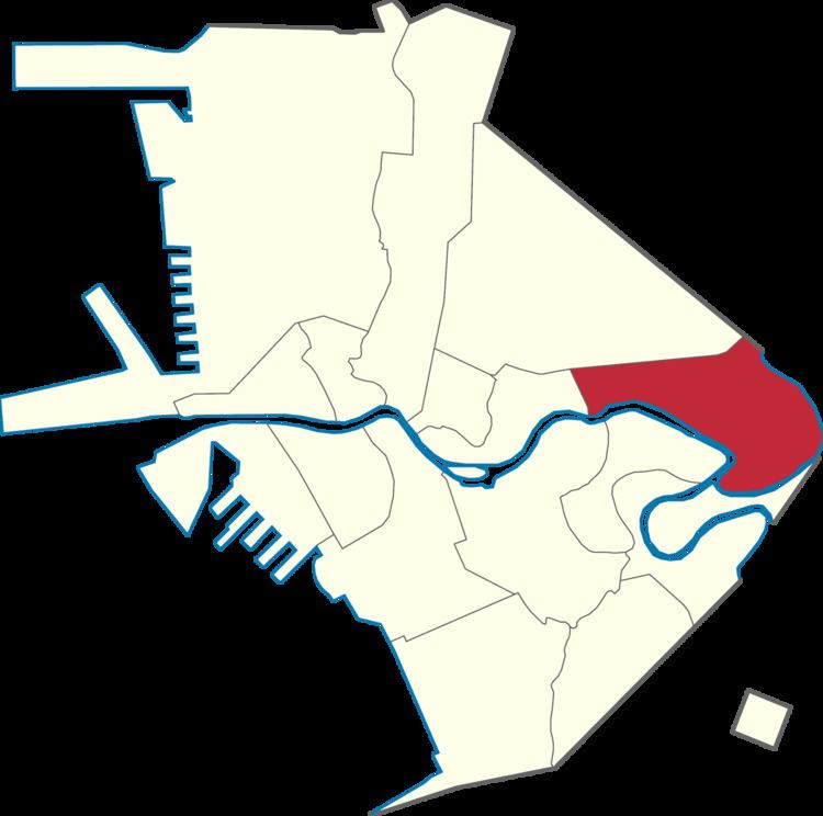
Map of Santa Mesa, Manila, Metro Manila, Philippines
Santa Mesa was formerly a part of the Sampaloc district, from which it was partitioned and separated after it had its own parish in 1911. The parish is now known as Old Sta. Mesa (Poblacion), a street which extends from Victorino Mapa Street to Magsaysay Boulevard. The Santa Mesa is a part of the 6th District of Manila and has 49 barangays (Barangays 587-636). It has a population of 98,901 as of 2007.
Coke spot edit sa santa mesa manila philippines aggressive inline skating
Etymology
The name is given by the Jesuits derived from the name Santa Mesa de la Misericordia meaning "Holy Table of Mercy". Which comes from the Titular Parish Patron The Sacred Heart of Jesus, it is known as the ( "The Center of The table is the Sacred Heart which all Graces and Mercy flowed down " ) The Tuazon family which is the landowner of Santa Mesa during the Spanish colonial period offered an obra pía ("pious work"), and provided social services to the people. Another possible derivation is from the Spanish for "Holy Mass".
History
The Town of Santa Mesa was situated in the alluvial deposits at the confluence of Pasig and San Juan Rivers. It was owned by a Jesuits religious order during the Spanish Era, and it is in this period that Santa Mesa got its name. Santa Mesa is better known for its role in the Philippine–American War, in which the area became a battlefield during the Philippine-American War. The conflict started when Pvt. William W. Grayson shot a Filipino soldier in San Juan Bridge between Santa Mesa and San Juan. (In late 2003, the National Historical Commission of the Philippines had determined that the conflict did not happen on San Juan Bridge, but at the juncture of Sociego and Silencio Streets.)
Up until the early American period, Sta. Mesa was just one of the barrios that comprised the Sampaloc area of Manila. In 1911, it became a separate religious community district, which divided Sampaloc into two parishes. The created parish is now known as the Old Santa Mesa, which extended from V. Mapa to Sta. Mesa Boulevard. The neighborhood was composed of wealthy Spanish and Filipino families who built summer houses which is Sociego Mansion former home of the Tuason Family and Carriedo Mansion home of the former Governor General is located attracted to Santa Mesa’s cooler climate and the picturesque streets that were lined with ylang-ylang trees. The abundance of these trees started a perfume industry — flowers were harvested, pressed and the oil were exported in great quantities to perfumeries in France.
The small community became the location of the hospital to treat the wounded during World War II. The town experienced its growth after the war. Santa Mesa was the site of a 1950s suburban development because of its proximity to central Manila. The Santa Mesa Market was constructed around this period. It was a big shopping complex, and became popular for the selling of Post eXchange goods from U.S. bases in the Philippines.
Sampaloc and Santa Mesa was absorbed by Manila in the 19th Century, along with other towns and settlements. When the Congressional Districts of Manila was created, Sta. Mesa was separated from Sampaloc, falling to the jurisdiction of District 6. The national census still considers Sta. Mesa as a part of Sampaloc.
Geography
Santa Mesa is located in the eastern section of the City of Manila. It is bounded to the west by Lacson Avenue separating it from San Miguel; by Ramon Magsaysay Boulevard to the north bordering it from Sampaloc. The northeast boundary of Santa Mesa is west of SM City Sta. Mesa shopping mall. Although the mall has "Santa Mesa" on its name, it is located in Quezon City very near the city limits of Manila.
The southwestern side of Santa Mesa is along Pasig River while the southern and eastern sides are along San Juan River. Across San Juan River are the cities of San Juan to the east and a small portion of Mandaluyong City to the southeast. Across Pasig River, are the Manila areas of Santa Ana to the south and Pandacan to the southeast.
The topography of the area is relatively flat as some of the natural variations in elevations have been evened out due to urbanization.