Postal codes 8661, 8662, 8663, 8664 | Time zone CET (UTC+1) Area codes 03856, 03858 | |
 | ||
Sankt Barbara im Mürztal is since 2015 a market town in Styria, Austria, with 6,726 inhabitants (as of 1 January 2016) in the judicial district of Mürzzuschlag and in the political district of Bruck-Mürzzuschlag in Styria. As part of the municipality structural reform in Styria, the municipality, which was founded on 1 January 2015, was formed by the merger of the independent municipalities:
Contents
- Map of Mitterdorf im MC3BCrztal 8662 St Barbara im MC3BCrztal Austria
- Geography
- Municipality arrangement
- Politics
- Economy and sights
- Transportation
- Industry
- Buildings
- Notable people
- References
Map of Mitterdorf im M%C3%BCrztal, 8662 St. Barbara im M%C3%BCrztal, Austria
This was based on the Styrian municipality Structural Reform Act, StGsrG.
In this case, no major part of one of the (three) outlying communities was used as a new name, but only the district name "Mürztal" (Murtal). The new community is named after the patron saint of miners, Saint Barbara. A Barbarakirche Barbara Church was built in 1986, in what is now the district Mitterdorf.
Geography
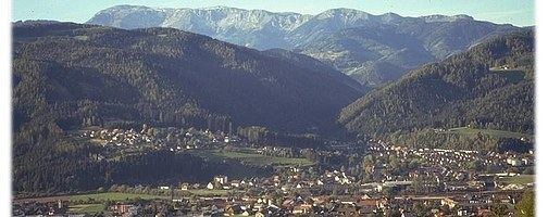
The center in the district of Mitterdorf is situated at an altitude of 587 m (1,926 ft) above sea level. St. Barbara im Mürztal is on the river Mürz. Small tributaries are the Small Veitsch (Kleine Veitsch brook), which in turn in the Great Veitsch opens (Große Veitsch), which unites in Mitterdorf with the Mürz river. Further, significant for the place tributaries are the Scheibsgrabenbach creek, which emptied in Wartberg in the Mürz, and the Sonnleitenbach, which flows into Mitterdorf in the Mürz.
The highest elevation of the municipality forms the massif Hohe Veitsch, with an altitude of 1,981 m (6,499 ft), and simultaneously forms a natural boundary to the west and north-west of the municipality. To the west is the Pretalsattel (1,069 m or 3,507 ft above sea level), as a compound in the Stübmingtal, Turnau and the Aflenzer Basin.
In the east and southeast of the town, borders the town of Fischbacher Alpen.
Municipality arrangement
The municipal area covers seven towns (in parentheses inhabitants as at 1 January 2016):
The community consists of the cadastral (Katastralgemeinden): Großveitsch, Kleinveitsch, Lutschaun, Mitterdorf, Niederaigen, Scheibsgraben, Veitsch Dorf and Wartberg.
Politics
Regierungskommissär (von der steiermärkischen Landesregierung bestellt)
Economy and sights
Transportation
The town lies on the southern railway, has 2 train stations of ÖBB ("Mitterdorf - Veitsch" or "Wartberg im Mürztal") and is accessible on the Semmering Schnellstraße S 6 (road exit "Mitterdorf"). The town can also be reached via the L 102 (Veitscherstraße) from Turnau or via the L 118 (Semmering Begleitstraße) from Kindberg and Krieglach.
Since 2016-07-18, a bus of the Mürztaler transport company is run from Kapfenberg and interconnects all 3 districts:
Route 85 (Pretal-) Groß-Veitsch - (Dorf-Veitsch-) Niederaigen - Mitterdorf im Mürztal - Wartberg im Mürztal station.Industry
Mining (magnesite from 1881), production of refractory products for smelting furnaces, steel production and processing have a long tradition and are still significant today in the area:
