
Topo map Google topographic map Easiest route Hiking | Elevation 3,636 m Parent range Singalila Ridge | |
 | ||
Location Darjeeling district, West Bengal, India Similar Phalut, Kangchenjunga, Mount Pandim, Makalu, Lhotse | ||
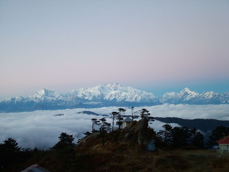
Sandakphu or Sandakfu or Sandakpur (3636 m; 11,941 ft) is the highest peak in the district of Ilam, Nepal and West Bengal, India. It is the highest point of the Singalila Ridge in Darjeeling district on the West Bengal-Nepal border. The peak is located at the edge of the Singalila National Park and has a small village on the summit with a few hostels. Four of the five highest peaks in the world, Everest, Kangchenjunga, Lhotse and Makalu can be seen from its summit. It also affords a pristine view of the entire Kangchenjunga Range.
Contents
Map of Sandakphu, 57300, Nepal
Nepal
The trekking starts from Ilam Bajar via Mai Pokhari, Maimajhuwa, Mau, Kaalpokhari Bikhe Bhyanjyang to Sandakpur.
India
The trek along the Singalila Ridge to Sandakphu and Phalut is one of the most popular ones in the Eastern Himalayas due to the grand vistas of the Kangchenjunga range and the Everest range which can be seen from the ridge, and also for the seasonal wildflower blooms and birding. Treks begin at Manebhanjan which is 28 km (approx. 1 hour by road) from Darjeeling.
Ascent
The trekking routes inside the Singalila National Park have four legs or stages.
Descent
Panorama of Peaks seen from Sandakphu and Phalut
Baruntse ( 7220m ), Chamlang ( 7319m ), Chomo Lonzo ( 7818m ), Lhotse ( 8516m ), Machhapuchhare ( 6993m ), Makalu ( 8462m ), Mount Everest ( 8850m ), Nuptse ( 7861m ), Kanchenjunga ( 8586m ), Talung ( 7349m ), Rathong ( 6679m ), Kabru N ( 7353m ), Koktang ( 6147m ), Simvo ( 6812m ), Frey ( 5853m ), Kabru S ( 7318m ), Kabru Dome ( 6600m ), Kabru Forked ( 6100m ), Pandim ( 6691m ), Tenchenkhang ( 6010m ), Jupono ( 5650m )
Villages At Glance: Gorkhey, Bhareng, Gairibas, Meghma, Maneybhanjyang, Rammam, Srikhola, Sepi, Molley, Gurdum