
Parent range Peninsular Ranges Elevation 1,060 m Country United States of America | Topo map USGS Otay Mountain Range Peninsular Ranges | |
 | ||
District San Diego County, California Biome California chaparral and woodlands Similar Coyote Mountain, San Diego Bay National, Lower Otay Reservoir, Otay Valley Regional Park, Whale Peak | ||
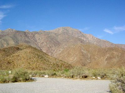
The San Ysidro Mountains are a mountain range in southern San Diego County, California. The range extends for a short distance into Baja California. The San Ysidro Mountains are part of the Peninsular Ranges System.
Contents
Map of San Ysidro Mountains, California 91917, USA
The highest point of the range is Otay Mountain, elevation 3,566 ft (1,087 m). The majority of the range is included in the Otay Mountain Wilderness Area.
FloraEdit
The native vegetation of the San Ysidro Mountains represents the coastal sage scrub of the California coastal sage and chaparral ecoregion (western faces); and plants of the California montane chaparral and woodlands ecoregion (inland). The San Ysidro Mountains are one of the few locations the rare Tecate Cypress (Cupressus forbesii) is found. This tree was once abundant in the higher elevations of the range as well as in its canyons. The San Ysidro Mountains were deforested of living foliage by wildfires in 2003 and 2007. Cupressus forbesii is a fire ecology dependent species, and there has been some evidence of regrowth starting.