
 | ||
Similar Mount Thayer, Tip Toe Falls, Branciforte Creek, Mount Bielawski, San Pedro Creek | ||
San Vicente Creek (Spanish for "St. Vincent") is a 9.3-mile-long (15.0 km) northern California coastal stream which flows entirely within Santa Cruz County (37.009394°N 122.194136°W / 37.009394; -122.194136) and discharges to the Pacific Ocean. Its waters rise on the west facing slopes of the Santa Cruz Mountains, and its mouth is at the unincorporated community of Davenport (which had originally been named after the creek).
Contents
Map of San Vicente Creek, California, USA
History
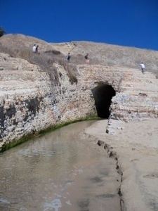
Originally, there was a tidal marsh at the mouth of San Vicente Creek, but this was filled in by a trestle and rampart built by a collaboration between the Ocean Shore Railway and the Southern Pacific Transportation Company in 1906. The creek was redirected through a tunnel blasted into the rock adjacent to its former course.
Prior to this San Vicente had been the premiere trout fishing stream in the county, so the fill caused some outrage in the local papers. An editorial in the Santa Cruz Surf at the time said: "The San Vicente Creek, beloved of the angler and the artist, has its mouth stopped by a vast dyke, and its throat choked into a tunnel, a saloon on its border, and its bed for miles denuded of the granite cobbles and sand beds. A sawmill is swiftly cutting out the timber and dirt and debris defile the pools and clog the riffles where lurked the gamey trout."