
Length 76 km Basin area 9,850 km² | Basin size 9,850 km (3,800 sq mi) Discharge 0.2 m³/s | |
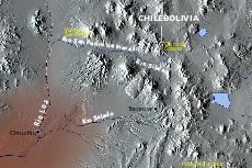 | ||
San Pedro de Inacaliri River, or called simply San Pedro River, is a river of Chile located in El Loa Province, Antofagasta Region. It begins at the confluence of the rivers Silala and Cajón, at an elevation over 4,000 m asl.
Map of R%C3%ADo San Pedro, Calama, Antofagasta Region, Chile
A part of its flow is diverted (between 50 and 60 l/s) and conducted across the desert to Chuquicamata for domestic water supply. About 8 km south, the waters of the river disappear in a floodplain area to reappear 15 km downstream at the so-called Ojos del San Pedro in the form of a partially overground stream, at the eastern border of a salt flat with a surface of 5 km².
Before discharging into Loa River, the river skirts the San Pedro volcano, where it has carved a 100-m-deep canyon through a rhyolite lava flow.
References
San Pedro de Inacaliri River Wikipedia(Text) CC BY-SA