
Area 1,626 km² | Founded 1870 Population 26,856 (2013) | |
 | ||
Website www.co.san-jacinto.tx.us Rivers Trinity River, Peach Creek, Winters Bayou | ||
San Jacinto County (/ˌsæn dʒəˈsɪntoʊ/ SAN ja-SIN-toh) is a county in the U.S. state of Texas. As of the 2010 census, its population was 26,384. Its county seat is Coldspring. The county's name comes from the Battle of San Jacinto which, in 1836, secured Texas' independence from Mexico and established a republic.
Contents
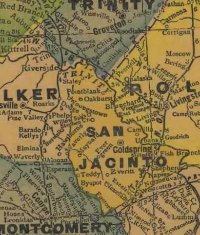
- Map of San Jacinto County TX USA
- Geography
- Major highways
- Adjacent counties
- National protected area
- Demographics
- Texas Senate
- Texas House of Representatives
- Education
- Cities
- Census designated places
- References
Map of San Jacinto County, TX, USA
Geography
According to the U.S. Census Bureau, the county has a total area of 628 square miles (1,630 km2), of which 569 square miles (1,470 km2) is land and 59 square miles (150 km2) (9.3%) is water.
Major highways
The TTC-69 component (recommended preferred) of the once-planned Trans-Texas Corridor went through San Jacinto County.
Adjacent counties
National protected area
Demographics
As of the census of 2000, there were 22,246 people, 8,651 households, and 6,401 families residing in the county. The population density was 39 people per square mile (15/km²). There were 11,520 housing units at an average density of 20 per square mile (8/km²). The racial makeup of the county was 83.64% White, 12.64% Black or African American, 0.46% Native American, 0.28% Asian, 0.07% Pacific Islander, 1.63% from other races, and 1.28% from two or more races. 4.87% of the population were Hispanic or Latino of any race.
There were 8,651 households out of which 30.00% had children under the age of 18 living with them, 60.20% were married couples living together, 9.70% had a female householder with no husband present, and 26.00% were non-families. 22.60% of all households were made up of individuals and 10.10% had someone living alone who was 65 years of age or older. The average household size was 2.55 and the average family size was 2.98.
In the county, the population was spread out with 25.20% under the age of 18, 7.40% from 18 to 24, 24.90% from 25 to 44, 26.60% from 45 to 64, and 15.90% who were 65 years of age or older. The median age was 40 years. For every 100 females there were 100.50 males. For every 100 females age 18 and over, there were 97.40 males.
The median income for a household in the county was $32,220, and the median income for a family was $37,781. Males had a median income of $34,614 versus $22,313 for females. The per capita income for the county was $16,144. About 15.10% of families and 18.80% of the population were below the poverty line, including 22.80% of those under age 18 and 17.60% of those age 65 or over.
Texas Senate
District 3: Robert Nichols (R)- first elected in 2006.
Texas House of Representatives
District 18: John Otto (R)- first elected in 2004.
Education
School districts include