
GNIS ID 417900 | Length 109 km | |
 | ||
Main source River mouth Confluence of the Salt Fork and the Middle Fork forming the Vermilion River west of Danville, Illinois531 ft (162 m) Progression | ||
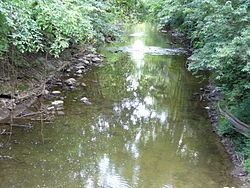
The Salt Fork is a tributary of the Vermilion River located in Illinois.
Contents
The Salt Fork owes its name to saline springs that provided natural salt licks for animals, and which were used for production of salt by Native Americans and early settlers. The springs were located about eight miles west of Danville, to the south of Muncie, Illinois. The upper reaches of the Salt Fork do not contain saline springs.
In its natural state, the Salt Fork drained a vast upland marsh between Urbana and Rantoul. The Salt Fork has been extended into these marshes by drainage ditches. Including the ditches, the Salt Fork is about 70 miles (110 km) long.
Parks and access points
Cities and towns
The following cities, towns and villages are in the Salt Fork watershed:
Counties
The following counties are in the Salt Fork watershed: