
Length 61 km | ||
 | ||
The Salmon Falls River is a tributary of the Piscataqua River in the U.S. states of Maine and New Hampshire. It rises at Great East Lake and flows south-southeast for approximately 38 miles (61 km), forming the border between York County, Maine, and Strafford County, New Hampshire.
Map of Salmon Falls River, United States
The Salmon Falls River joins the Cochecho River near Dover, New Hampshire to form the Piscataqua River.
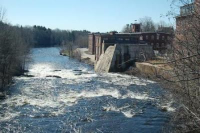
It provides hydroelectric power at the New Hampshire towns of Milton, North Rochester, Somersworth, and Rollinsford, and in Maine at Berwick and South Berwick. The final three miles of the river, from South Berwick to the Piscataqua, are tidal.
Local Abenaki Indians called the river Newichawannock, meaning "river with many falls".
References
Salmon Falls River Wikipedia(Text) CC BY-SA