
Country United States Opening date 1910 Height 66 m Surface area 13.76 km² | Purpose Irrigation Type of dam Concrete gravity arch Catchment area 4,170 km² | |
 | ||
Owner(s) Salmon River Canal Company Address Salmon Falls Dam, Castleford, ID 83321, USA Similar Salmon Falls Creek, Milner Dam, Jarbidge Mountains, American Falls Dam, C J Strike Dam | ||
Fishing at the salmon falls dam
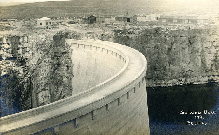
Salmon Falls Dam is a dam constructed across Salmon Falls Creek in Twin Falls County, Idaho in the United States. Located about 25 miles (40 km) south of Buhl, the masonry arch-gravity dam is 217 feet (66 m) high and 450 feet (140 m) long, impounding up to 230,650 acre feet (0.28450 km3) of water in Salmon Falls Creek Reservoir. When full, the reservoir extends for 17 miles (27 km) upstream, encompassing 3,400 acres (1,400 ha). The dam and reservoir control runoff from a drainage basin of 1,610 sq mi (4,200 km2).
Contents
The dam was built in 1910 to provide irrigation water storage, and is owned and operated by the Salmon River Canal Company. A secondary purpose is flood control: the dam has never spilled floodwaters with the exception of the heavy snowmelt of 1984. Salmon Falls Creek Reservoir is also a popular recreational lake, and is considered one of the best fisheries in southern Idaho.