
Country Philippines Barangays ZIP code 2818 Local time Wednesday 11:23 PM | District Lone District of Abra Time zone PST (UTC+8) Area 128.6 km² Province Abra | |
 | ||
Region Cordillera Administrative Region (CAR) Weather 25°C, Wind SE at 5 km/h, 72% Humidity Neighborhoods Naguilian, Bazar, Salldeng, San Guillermo | ||
Welcome to sallapadan abra
Sallapadan, officially the Municipality of Sallapadan (Ilocano: Ili ti Sallapadan, Filipino: Bayan ng Sallapadan), is a municipality in the province of Abra in the Cordillera Administrative Region (CAR) of the Philippines. The population was 6,622 at the 2015 census. In the 2016 electoral roll, it had 4,855 registered voters.
Contents
- Welcome to sallapadan abra
- Map of Sallapadan Abra Philippines
- Bp mag anak sa sallapadan abra na food poison
- Geography
- Barangays
- Demographics
- References
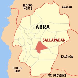
Map of Sallapadan, Abra, Philippines
Bp mag anak sa sallapadan abra na food poison
Geography
Sallapadan is located at 17°28′N 120°46′E.
According to the Philippine Statistics Authority, the municipality has a land area of 128.62 square kilometres (49.66 sq mi) constituting 7000309000000000000♠3.09% of the 4,165.25-square-kilometre- (1,608.21 sq mi) total area of Abra.
Barangays
Sallapadan is politically subdivided into 9 barangays.
Demographics
In the 2015 census, Sallapadan had a population of 6,622. The population density was 51 inhabitants per square kilometre (130/sq mi).
In the 2016 electoral roll, it had 4,855 registered voters.