Trisha Shetty (Editor)

Salisbury Island (Russia)

Updated on
Edit
Like
Comment
Share on FacebookTweet on TwitterShare on LinkedInShare on Reddit
Area
  
960 km²

Salisbury Island (Russia) httpsuploadwikimediaorgwikipediacommonsthu

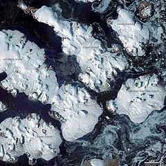
Salisbury Island, (Russian: Остров Солсбери; Ostrov Solsberi) is an island located in the central area of Franz Josef Land, Russia.

Contents

Map of Salisbury Island, Arkhangelsk Oblast, Russia

Salisbury Island is relatively large and long, having a surface of 960 km². Its highest point is 482 m and practically the entire surface of the island is glacierized.

Salisbury Island is part of the Zichy Land subgroup of the Franz Josef Archipelago. It has very little open sea around it, being wedged between Luigi Island and Champ Island on its southwestern shores, Ziegler Island in the northeast and Wiener Neustadt Island in the east.

This island was named after geology Professor Rollin D. Salisbury (1858-1922), of the University of Chicago. Salisbury was second-in-command on the Peary relief expedition.

Salisbury Island in the Franz Josef Archipelago should not be confused with Salisbury Island, in Canada.

Adjacent Islands

  • Elisabeth Island (Остров Елизаветы; Ostrov Yelizavety) is a 5 km long oval-shaped island lying 7 km off Salisbury Island's northwestern end. Unglacierized; highest point 121 m. This island was named after Archduchess Elisabeth Marie of Austria, daughter of Crown Prince Rudolf, after whom Rudolf Island, Franz Josef Land's northernmost island, was named.
  • Ostrova Kuchina (Острова Кучина). These are two very small islets off Salisbury Island's northeastern coast; one of them is very close to the shore. They were named after Russian Arctic explorer Alexander Kuchin, the only Russian on Amundsen’s expedition to the South Pole on the Fram. Kuchin was lost in Vladimir Rusanov's ill-fated expedition from Spitsbergen on ship Gerkules in 1912.
  • References

    Salisbury Island (Russia) Wikipedia


    Similar Topics