
Highest elevation 554 m (1,818 ft) Elevation 554 m | Coordinates (?) Population 0 Area 448 km² | |
 | ||
Archipelago | ||
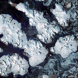
Ziegler Island (Russian: Остров Циглера; Ostrov Tsiglera) is an island in Franz Josef Land, Russia.
Contents
Map of Ziegler Island, Arkhangelsk Oblast, Russia
This island is 45 kilometres (28 miles) long, stretching from the NW to the SE. Its area is 448 square kilometres (173 square miles) and it is almost completely unglacierized. The highest point on Ziegler Island is 554 metres (1,818 feet). Ziegler Island is part of the Zichy Land subgroup of the Franz Josef Archipelago.
Adjacent islands
History
This island was named after New York businessman William Ziegler, leader of the 1901 Baldwin-Ziegler North Pole Expedition, on ships America, Fridtjof and Belgica, and of the 1903–1905 Ziegler-Fiala Polar Expedition. The Austrian observing site Payer–Weyprecht (probably 81°06′N 56°11′E) was established around the start of the 20th century on this island.