
Time zone ECT (UTC-5) Website www.salango.com.ec | Climate BWh Local time Wednesday 3:59 AM | |
 | ||
Weather 25°C, Wind NW at 3 km/h, 95% Humidity | ||
Ecuador loves surf puerto l pez salango ayampe las tunas manab english
COMUNIDAD SALANGO is a rural parish of Puerto López Canton, Manabí Province, Ecuador
Contents
- Ecuador loves surf puerto l pez salango ayampe las tunas manab english
- Map of Salango Ecuador
- Location and dimensions
- Description
- Economy
- Worldview
- Salango Salango Town Comuna Salango
- Salango Museum
- Geopolitics
- Land legalization
- References
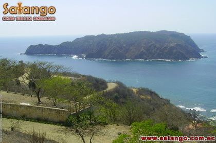
Map of Salango, Ecuador
Location and dimensions
Description
Community venues Río Chico.
Economy
Natural Resources: Fishery, Flora, Fauna Marina
Factory :Fishery.
Tourism: Whale watching, beach, museum, crafts, diving, ecotourism trails, snorkeling, trekking, scenic beauty, flora and fauna, cultural events, archaeology.
The Salango community has deep ancestral roots that represent about 5,000 years of history and culture.
Worldview
Salango is a pre-Columbian settlement that is located at the southern end of a sandy cove on the south coast of the province of Manabi. Salango Island is located just off the coast.
The worldview of the people has been developed through the different cultures that have existed here starting from the Valdivia culture, Machalilla, Engoroy- Chorrera, Bahia, Guangala and Manteños.
Through the archaeological remains found, it is surmised that their ancestors’ spirituality and understanding of the world around them was very large, but in particular, it was bound up with their environment as alive, of ocean and hilly forest, preserving and protecting it as well as transmitting their spiritual knowledge to new generations.
The Pueblo Manta that consists of the comunas Salango, Las Tunas, El Pital and Agua Blanca keeps alive these spiritual, cultural and pre-Columbian symbols of their own ancient worldview, which are presented in their cultural celebrations.
The worldview of the Pueblo Manta has always been connected to the shell spondylus, from the Valdivia culture until today.
Salango. Salango Town. Comuna Salango
Salango is located on the shores of the Pacific, in southern Manabi Province, in the buffer zone of the Machalilla National Park. The community seeks to consolidate its development process with the promotion of one of the main features the community-based ecotourism, taking advantage of the natural and cultural resource that are related to the ancient heritage of those who settled in this sector.
Amongst its natural attractions is the island of Salango, home to beautiful species of seabirds like blue-footed boobies, frigates, pelicans among others; just off the island’s pristine beach is the marine sanctuary, a site with schools of tropical fish and coral reefs, ideal for diving.
In the heart of the community is the Research Center and Museum Salango CIMS that protects and exhibits in its original place an archaeological collection of 245 pieces of cultural heritage that represent over 4500 years before the conquest. The center possesses laboratories and collections of archaeological, fauna, fish, and mollusks for studies and investigations. Part of the center includes the hacienda house that functions as a historic museum that recounts the last 100 years of Salango’s history.
Salango Museum
The museum grounds function as an educational center for deepening the understanding of the area’s cultural and marine resources. Programs are provided for children and adults of different educational levels.
Geopolitics
They are located on the southern coast of Ecuador, in the canton Puerto Lopez, Manabi province. The Salango community is located along the south of the Ecuadorian coast, in the canton of Puerto López, Manabí Province. It is composed of villages of Salango Rio Chico.
Land - legalization
Salango acquired legal status as a commune by in the No. 074 Agreement in the Ministry of Agriculture and Livestock on October 30, 1979.
After a process of analysis and discussion of its historical past and identification, it was recorded in the Development Council for Nationalities and Peoples of Ecuador CODENPE by Agreement 016 on 19 April 2004, as a community of ancestral roots.
It has a communal territory of 2536 hectares. Its principal economic activity is fishing.
The Community of Salango of the Canton Puerto Lopez, Manabi Province, holds property rights to a territory about 2,536 hectares, is made up of the small towns of Salango and Rio Chico.
The communities on the south central coast of Ecuador including Salango, are descendants of the Pueblo Manta Huancavilca, with 5,000 years of history and culture. The first settlements belonged to the Valdivia culture, followed by Machalilla, Engoroy- Chorrera, Bahia, Guangala and culminated with the so-called Regional Integration Period Manteña (800-1530 AD)
In 1526, there was the first contact between Spanish and native sailors of Salango. At that time there was a powerful chiefdom known as Salangome, which was the nucleus of a "League of Merchants" that dominated the sea trade, devoting their trade to a large variety of seafood, including the shell "spondylus."
During the colonial era a religion unknown to our Indians was imposed. By a synod of 1535, the original language of Ecuador's coastal communities was abolished and the Spanish language imposed, which is why now there are only traces and words of our native language as colonche, vine, Tuzco, Sercapez, Valdivia, and Salango.
Due to the natural advantages they have, these communities have been prized by external interests that have consistently affected their territories, natural resources as well as cultural heritage and history.
In 1937 the Ecuadorian government enacted the Law of Organization and Management of Communes, which intended to protect and ensure the existence and functioning of rural peasant communities and administratively place them under the protection and supervision of the Ministry of Agriculture and Livestock. The creation of a comuna in an area included "every town that does not have the status of parish and was known as annexed, neighborhood, community, bear the name of community."
However, this Act was based on the idea that all rural communities are peasant communities, but it did not acknowledge or recognize the cultural and historical diversity of towns and ancestral communities.
Subsequent reforms have not changed this view; therefore, at present time most of its provisions have fallen into conflict with constitutional law and international norms that protect indigenous communities.
The Salango commune, aware of its historical and ancestral roots, in the exercise of its collective rights guaranteed in the Ecuadorian constitution and in the provisions of Convention 169 of the International Labour Organization ILO, in a free and autonomous way, took the decision to separate the regime of the Communal rights and its former legal status; consequently the new status of the Community Salango was recorded under Agreement No. 016 on April 19 of 2004 in the Consejo de Desarrollo de las Nacionalidades y Pueblos del Ecuador CODENPE, an agency under the Presidency of the Republic, authorized in Executive Order No. 386 RO 86 on December 11 of 1998, that is responsible for defining policies for the reconstruction, strengthening and development of the indigenous towns and communities in the country.
For the management of their territory, natural resources, biodiversity, cultural heritage, and social organization, the Comprehensive Plan for Community Development of Salango "PIDCOSA", was developed at the beginning of 2004 and became the basis for the Parish Development Plan and the projects "Ecotourism and Community Development of Handicraft" and "Production of Ecosystem Services".
In 2001 a section of ocean to the north of the island Salango was declared a marine sanctuary by the Salangome Ecological Association, in order to develop a site of conservation, especially conservation of those species that reside on the seafloor. The site also serves as a venue for research and tourism in Salango.
As part of PIDCOSA, the "Community Management Research Center and Museum Salango CIMS," project was developed in the beginning of 2005, through which the community officially took over the management of CIMS. This was accomplished once the National Institute of Cultural Heritage declared the archaeological collections, which include 245 museum pieces, as belonging to the cultural heritage of the Commune Salango.
On March 31, 2011 the Ecuadorian Ministry of Tourism, issued the regulations for the Registration of Tourist Community Centers, in which traditional communities legally organized and trained can develop community tourism activities.