
Age of rock Jurassic to Cretaceous Prominence 578 m Parent range French Prealps | Elevation 1,379 m Mountain range French Prealps | |
 | ||
Location Haute-Savoie, Rhône-Alpes, France Similar Vuache, Voirons, Semnoz, Mont Blanc, Le Môle | ||
The Salève is a mountain of the French Prealps located in the departement of Haute-Savoie (France). It is also called the "Balcony of Geneva".
Contents
- Map of SalC3A8ve 74160 Beaumont France
- GeographyEdit
- From prehistory to green tourismEdit
- Le syndicat mixte du Salve and the Maison du SalveEdit
- Tibetan templeEdit
- The Salve in literatureEdit
- The Salve in paintingsEdit
- References
Map of Sal%C3%A8ve, 74160 Beaumont, France
GeographyEdit
Geographically, the Salève is a mountain of the French Prealps located in the department of Haute-Savoie, but geologically a part of the Jura chain, as the Vuache is.
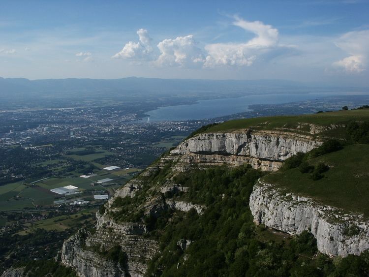
Below the Salève is the Geneva urban area where more than 700,000 people live.
The Salève consists of the Pitons, the Grand and the Petit Salève, and culminates at 1379 meters at the Grand Piton. It is accessible by a cable car since 1932 (rebuilt in 1983), the Salève stretches between Étrembières in the north and the suspension bridge de la Caille in the south. Between 1892 and 1935, the Salève was served by the first electric rack railway in the world.
The eastern side of the Salève dives under the molasse of the Bornes Massif while the abrupt mountain slope facing Geneva is subject to erosion. The vegetation - or its absence - enhances the limestone's layers. This side of the mountain is slit by several narrow and deep gorges, among which the Grande Varappe, which at the end of the 19th century gave its name to the activity of rock climbing in French. This discipline developed intensely there, at a time when it was only beginning.
The Monnetier valley, separating the Petit and the Grand Salève, is due to glaciary erosion. Modern geologists now think that this valley was dug by the subglaciary currents in a fissured region between the Petit and the Grand Salève, and not by the Arve as was assumed earlier.
From prehistory to green tourismEdit
Between 12,000 and 10,000 BC, the Salève hosted a magdalenian site. Since 1833, the physician from Geneva François Isaac Mayor, then the minister Taillefer and the dentist Thoily explored the mountain's past. The cliff near Veyrier turned out to be a prehistoric shelter. Bones (partridge, reindeer, horse, marmot...), flint and engraved wood was found in a dozen places, caves, shelters or settlements. There was a dolmen at Aiguebelle.
Between the Neolithic and the Bronze age, the settlements became more sedentary (Bossey, Chaffardon). An oppidum was erected on the Petit Salève around 1000 BC.
The Salève offers a magnificent panorama over the Geneva agglomeration, Lake Geneva, the south of the Jura mountains, the Prealps, Lake Annecy and the Mont Blanc. It is used for leisure time activities by the inhabitants of Geneva due to its proximity to the city (for this reason it is often called the "mountain of the Genevans"). One can practice rock climbing, hiking, mountain biking, paragliding, hang gliding, model aircraft, speleology as well as skiing at the Col de la Croisette. It can be accessed from the center of Geneva by public bus (No. 8, 34, 41) to Veyrier-Ecole or Veyrier-Douane. While the Salève is open to everybody for free, it also hosts agriculture - the cows of the Salève supply Geneva with milk - and forestry.
"Le syndicat mixte du Salève" and the "Maison du Salève"Edit
The "Syndicat mixte du Salève" was created in 1994 and regroups the twenty communes on whose ground the Salève is located. Its objective is to appreciate and protect the mountain which is a "preserved island" in the middle of a French-Suisse territory that is highly urbanized with more than 700.000 inhabitants.
The syndicat opened the "Maison du Salève" in September 2007 in an ancient Mikerne farm house dating from 1733. This documentation center presents all aspects of the mountain: its history, patrimony, nature, sports and leisure. In the same year, it developed a charter for sustainable development of the Salève trying to reconcile the conservation of the massif with its increasing frequentation with a vision on 30 years. The "Maison du Salève" hosts a permanent exposition, temporary exhibitions as well as guided tours, excursions and conferences about the local patrimony and the environment.
The syndicat involves in its three work groups - agriculture, tourism and leisure, access and transportation - all users of the Salève, i.e., communes, sport clubs, environment protection associations, restorations, farmers, hunters, tourism offices etc.
Tibetan templeEdit
Shedrub Choekhor Ling is a center of Tibetan Buddhism on the Salève, founded in 2010. It is under the direction of the Sangha sur Salève association.
The Salève in literatureEdit
The Salève in paintingsEdit
The Salève occurs on one of the first European paintings depicting a realistic landscape, La Pêche Miraculeuse by Konrad Witz created in 1444.