
Founded 1832 Time zone AST (UTC−4) Population 1,770 (2011) Local time Tuesday 12:02 PM | Incorporated November 9, 1966 Area 6.43 km² Area code 506 | |
 | ||
Weather -2°C, Wind E at 16 km/h, 84% Humidity | ||
Saint-Antoine is a village in Kent County, New Brunswick, Canada. It is 35 km north of Moncton and 18 km Southwest of Bouctouche. Saint-Antoine's residents are Acadian; most speak French in its local variant, Chiac. Saint-Antoine is on Route 115 and Route 525. The village is called St. Anthony by English area residents.
Contents
Map of Saint-Antoine, NB, Canada
History
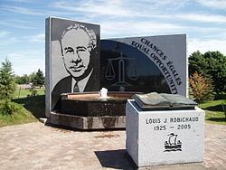
The village is named in honour of Anthony the Great. From 1966, it was called St. Anthony until it was changed to Saint-Antoine in 1969. The village was originally called Higho Settlement. Saint-Antoine was the birthplace of Louis Robichaud, Canada's first Acadian provincial premier.
References
Saint-Antoine, New Brunswick Wikipedia(Text) CC BY-SA