
Time zone CET (UTC+1) Population 27,616 (2007) | Region Normandy Intercommunality CREA Area 18.25 km² Local time Wednesday 4:04 AM | |
 | ||
Weather 9°C, Wind S at 10 km/h, 77% Humidity Colleges and Universities Institut national des sciences appliquées de Rouen, ESIGELEC | ||
Saint-Étienne-du-Rouvray is a commune in the Seine-Maritime department in the Normandy region in northern France.
Contents
Map of Saint-%C3%89tienne-du-Rouvray, France
History
Evidence of ancient habitation has been found on and around the site of modern-day Saint-Étienne-du-Rouvray including Neolithic tools (dated to 2000 years BC) as well as signs of Gallo-Roman settlements (200-300 years AD).
A hamlet called Sancti Stephani and dependent on the Abbey of Saint-Wandrille was reported in the ninth century in a royal charter. The village then developed along the road connecting Paris to Rouen. During the fifteenth and sixteenth centuries the parish had five hundred inhabitants. The population grew, benefiting from arable land near the river, as well as rich forests, moors and grasslands.
During the Revolution, in 1790, Saint-Étienne-du-Rouvray was constituted as a political administration. The town began to take its urban and industrial character from the mid-nineteenth century with the beginning of the industrial revolution and the arrival of the railway.
The first steam trains of Western Railway Company between Paris and Rouen began service in 1843, increasing the attractiveness of the town for industry. The 1860s saw the establishment of a large cotton factory creating hundreds of jobs, and led to the expansion of the town to accommodate its expanding workforce.
In the early twentieth century, the opening of the railway workshops of Quatre-Mares (1913), the arrival of the Fonderie Lorraine in 1916 and the Stationery Chapel (1928) reinforced the industrial character of the city.
In 1923, three years after the Tours Congress which saw the separation of the communist majority (KIS) and the minority Socialist (SFIO), Saint-Étienne-du-Rouvray became one of the first cities in France to elect a communist controlled council.
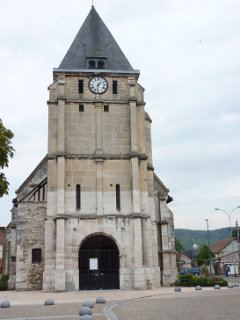
On 26 July 2016 two knife-wielding men, supporting the Islamic State of Iraq and the Levant, burst into a 16th-century church in Saint-Étienne-du-Rouvray, took five hostages and killed an 85-year-old Roman Catholic priest, the Reverend Jacques Hamel, before they were shot and killed by police.
Geography
Saint-Étienne-du-Rouvray is a large suburban town of light industry and forestry situated by the banks of the Seine, some 4 miles (6.4 km) south of the centre of Rouen on the D18 and the D18e roads. The commune is served by the Rouen tramway.
Twin towns
Saint-Étienne-du-Rouvray is twinned with Nordenham (Germany), Nova Kakhovka (Ukraine), and Gateshead, Tyne and Wear (UK).