
Country Philippines Time zone PST (UTC+8) Local time Tuesday 9:10 AM | District 2nd district of Bohol Area 69.61 km² Province Bohol | |
 | ||
Region Central Visayas (Region VII) Incorporated
Renamed 9 February 1949
21 June 1957 Barangay Weather 25°C, Wind NE at 19 km/h, 83% Humidity | ||
Sagbayan is a 4th municipal income class municipality in the province of Bohol, Philippines. According to the 2015 census, it has a population of 22,339. In the 2016 electoral roll, it had 14,394 registered voters.
Contents
Map of Sagbayan, Bohol, Philippines
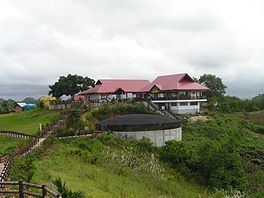
Its main attraction is Sagbayan Peak, which is a tourism site with
overlooking a scenic valley. While some similar hill formations are visible, it is not within the main Chocolate Hills area.
Sagbayan means "place for hanging", coming from the root word sagbay, which means "to hang" and referred to the practice of hanging deer hides on trees to dry after hunting expeditions.
History
Sagbayan was formerly part of the surrounding municipalities of Clarin, Inabanga, Carmen, and Balilihan. It was formed into a separate town by an Executive Order of President Elpidio Quirino on 9 February 1949, and named Borja, in honor of Salustiano Borja, the first elected civil governor of the Province of Bohol. It reverted to its original name in 1957.
In October 2013, Sagbayan was close to the epicenter of a magnitude 7.2 earthquake. The town suffered 12 fatalities and damage to almost 1,000 homes, as well as total destruction of its town hall.
Barangays
Sagbayan comprises 24 barangays:
Demographics
In the 2016 electoral roll, it had 14,394 registered voters, meaning that 64% of the population are aged 18 and over.