
Country Nepal Area 10,591 km² | Time zone Nepal Time (UTC+5:45) | |
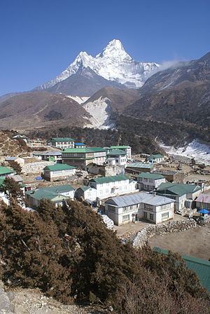 | ||
Points of interest Sagarmatha National Park, Gokyo Lakes, Khumbu Glacier, Kala Patthar, Ama Dablam Destinations Sagarmatha National Park, Lukla, Koshi Tappu Wildlife R, Namche Bazaar, Tengboche | ||
Snowfall at namche bazaar in the sagarmatha zone of north eastern nepal
Sagarmāthā (Nepali: सगरमाथा अञ्चल Listen ) is one of the fourteen zones located in eastern Nepal. It includes mountain districts of the Himalayas (including Mount Everest) in the north, hill districts in the center, and valley districts of the Terai in the south. It is bordered by China to the north, India to the south, the Kosi Zone to the east and the Janakpur Zone to the west.
Contents
- Snowfall at namche bazaar in the sagarmatha zone of north eastern nepal
- Map of Sagarmatha Nepal
- Sagarmatha zone the head in the great blue sky
- References
Map of Sagarmatha, Nepal
Sagarmāthā is divided into six districts:
The main city of the Sagarmāthā Zone is Rajbiraj which is also the headquarters. Other towns of the Sagarmāthā hill area are Katari, Okhaldhunga, Diktel, Salleri and Namche Bazaar; while Kathauna, Lahan, Fatepur, Rajbiraj and Siraha are in the outer Terai. Triyuga is an emerging city in the zone.
Sagarmāthā takes its name from the Nepalese name for Mount Everest, which is located in the very north of the zone within the Sagarmatha National Park (1,148 km²) in the Solu Khumbu district. Sagarmāthā means "the Head in the Great Blue Sky".